The most notable historical occupation in the Sidekan area, and the focus of this dissertation, is the Iron Age kingdom of Muṣaṣir. Despite the millennia of human settlement in this region, the historical record is comparatively bare. Apart from a handful of rare inscriptions, the history of Soran comes from reports and tales of outside travelers, conquerors, and spies. While Sidekan is the primary focus of this analysis, Soran and Sidekan are inextricably linked throughout history as two small refuges in the largely inhospitable northern Zagros Mountains. Thus, the history of Soran is vital for understanding the annals of its smaller neighbor, Sidekan. Further, the dearth of historical texts from Sidekan and Soran themselves forces us to examine the history of Sidekan largely through the lens of outsiders, with only small archaeological and ecological clues revealing the identity of its occupants. In this limited historical dataset, the Iron Age kingdom of Muṣaṣir stands apart as one of the few periods of note.
Across history, Sidekan appears only periodically in direct and indirect references. While literature and historical documentation only began referencing the area as Sidekan in the last few centuries, a combination of geographic and historical triangulation reveals the region’s identity throughout time. The dual geographic features of the Rowanduz Gorge and the Kelishin Pass provide immutable anchor points when using historical accounts to reconstruct the area. While the names of these features evolve over millennia, their unique characteristics provide a connection to the modern names. By utilizing geographic clues, the existence of an inscription at the Kelishin Pass, and data from an archaeological survey of Sidekan by Rainer Michael Boehmer in the 1970s, scholars now believe that the core of Muṣaṣir was in the area of the modern Sidekan subdistrict (Boehmer and Fenner 1973). Urartu, the mountainous Iron Age empire to the north, with its capital of Tušpa at Lake Van, revered Muṣaṣir. According to contemporary texts, Muṣaṣir was home to the temple of Ḫaldi, the head deity of the Urartian pantheon, bestowing the kingdom prominence to the Urartian rulers (Çifçi 2017, 257). Apart from references to Muṣaṣir, historical documentation of the area is minimal.
Preceding the Iron Age and Muṣaṣir, textual accounts from nearby regions suggest a possible identification of the area as Kakmum, although that identity is far from certain. The relationship between the Bronze Age occupation and the Iron Age is important for establishing the origins of Muṣaṣir as well as the Urartian Empire and its rulers. After the Iron Age and the fall of Urartu, Sidekan’s identity is far more obscure. Extrapolating from present names and geographical relationships indicates that a possible name of the area during the Classical Periods was Aniseni. This name appears periodically throughout history in reference to tribes or small sections of the area. After the Muslim Conquest, the area disappears from the historical record minus a few individual references to geographic features by travelers and geographers, noting the Kelishin Pass. Eventually, during the Ottoman rule, the Sorani Emirate arose, providing a concrete anchor to locate geographical polities around the core of the state, the Diana Plain. The name Sidekan does not occur as a noteworthy political entity during this time, but traveler’s accounts confirm continued occupation, albeit extremely limited and hostile to outsiders.
The overall history of the Sidekan region appears to begin with some occupation in the Late Bronze Age, before reaching its height and importance in the Iron Age, with neighboring empires and kings fighting to exert influence over the area. After Muṣaṣir’s temple and Ḫaldi’s fade into irrelevance, Sidekan shrinks and largely disappears from the historical record until after the Muslim conquest. History alone can not serve as evidence for the region’s irrelevance for a millennium, but it does suggest that Muṣaṣir’s role as a significant player in local geopolitics was short-lived. By combing the historical record and correlating periods of archaeological occupation, it becomes clear that Muṣaṣir’s thriving kingdom was abnormal for the region. Overviewing the history provides a window into the settlement patterns of the Sidekan area and places the region into context with its larger neighbors.
Early Bronze Age
Understanding and identifying the possible polities located in the Soran district during the Bronze Age requires an overview of the major states and groups in the Trans-Tigridian corridor, utilizing their relative locations and outside references to identify this mountainous region. The possible identification of this area is Kakmum, determined by locating various toponyms on the map of the Trans-Tigridian valleys and Zagros Mountain piedmont. Although textual sources provide limited information about the inhabitants and settlement itself, the descriptions help determine the origins of the later Iron Age state and establish the type of occupation in the area. Kakmum itself rarely appears in the textual records of the Mesopotamian plains and alluvium, but inscriptions from its better-known neighbor, Simurrum, note its importance in the machinations of the Trans-Tigridian potentates. Most of the key information about the mountain kingdoms comes from records of the larger Mesopotamian states throughout the Bronze Age, most notably the kings of the Ur III state.
Simurrum
A primary adversary and major source of textual information about Kakmum was the kingdom of Simurrum. Locating Simurrum with precision is vital for the relative positioning of Kakmum. Simurrum appears in various textual sources from the 24th through 18th centuries BCE (Altaweel et al. 2012, 9). Early Dynastic kings boast of capturing the polity and describe its character as a place “between the basket and the boat” (Alster 1997, 84, 104). Sargon of Akkad and his successor Naram-Sin both campaigned against the kingdom, dedicating year names to their attacks on Simurrum (Frayne 1993, 96; 1997, 246). Later, a Gutian named Erridu-Pizir records a king of Simurrum named KA-Nišba instigating hostilities among his people and neighboring Lullubum against the ruling Gutians (Frayne 1993, 224). After the fall of Guti, king Šulgi of the resurgent Ur III dynasty engaged in five separate campaigns against Simurrum in year names 25, 26, 32, 44, and 45 (Ahmed 2012, 237). Hallo (1978, 72) postulates that Simurrum’s vital location controlling routes between the Iranian plateau and Mesopotamia drove Šulgi’s apparent obsession with its conquest. The intensity of conflict led to him naming three of the years the “Hurrian wars” against Simurrum and nearby Karhar (Hallo 1978, 82). After the short period of Ur III rule over the area, a strong independent king of Simurrum rose to power, Iddin(n)-Sin, credited for controlling vast swaths of the Trans-Tigridian corridor and erecting monuments in his honor (Edzard 1957, 63; Walker 1985, 186-90; Whiting 1987, 22; Ahmed 2012, 220-275).
With attestations spanning the Early Dynastic Period to the Early Bronze Age, Simurrum serves as an anchor point for topographical names at the time. Although there is some debate over the exact location of the kingdom, most scholars agree on a general location east of the Tigris, in the valleys and semi-mountainous areas of the Trans-Tigridian corridor (Billerbeck 1898, 4; Meissner 1919; Forrer 1920; Gelb 1944, 57; Edzard 1957; Frayne 1997; Altaweel et al. 2012). The exact locations, however, have some variation. In the late 19th century, Billerbeck identified Simurrum and Zaban as the same localities, placing them on the Lower Zab River (Billerbeck 1898). Meissner then suggested a location near Kirkuk, mainly utilizing a Šulgi date-formula in which Simurrum and Lullubum are seemingly related and texts that conflate Simurrum with Zaban (Meissner 1919). Although multiple subsequent publications continued the identification with Zaban, Forrer and Weidner disagreed and determined that the two topographical names were distinct (Forrer 1920; Weidner 1945). The two names may indeed refer to the same entity, but Simurrum is the earlier name while Zaban arises in the Old Babylonian period, possibly under Sillī-Sîn and Ilūnā of Ešnunna, indicated by an archive of texts from Mê-Turran (Frayne 1997).
More recent publications argue for different locations closer to the Mesopotamian plains or further into the Zagros Mountains. Frayne originally proposed a locale much farther south, specifically on the Sirwan River, near Kifri, at the site of Qalat Shirwana, using the relative positions of Simurrum and its neighbors as the predominant factor (Frayne 1997). As part of his argument, he noted the similarities between the modern Sirwan and Simurrum names and the substantial defensive location of the town (Frayne 1997, 267–68). However, in a later article, he changed his proposed location to northeast of the Darband-i Khan, specifically “the wide river basin west to the modern Av-i Tangero,” (Frayne 2011, 511). Radner locates Simurrum in the Shahrizor, farther to the northwest, based on its fertility and natural defensive advantages, as well as the locations of rock reliefs and other topographic names (Altaweel et al. 2012, 9–11). The location of Mount Nišba, its identity known from later Assyrian sources as the Hewrman range, is of some importance for the kings of Simurrum and aides Radner’s identification. The findspot of the recently published Halidany Inscription at the archaeological site of Rabana, on the slopes of the Pira Magrun Mountain, led Ahmed (2012, 293-95) to suggest the site as the temple to Nišba, on the mountain of the same name. Using that evidence, in part, he arrived at the same conclusion for the kingdom’s location in the Shahrizor Plain, north of the Darband-i Khan Pass (Ahmed 2012).
Turukku
Simmurum’s positioning and relationship with its neighbors assist in understanding the location and identity of another Bronze Age polity, Turukku. Inscriptions of Simurrum, from the time of Iddi(n)-Sin, and the Old Babylonian era archive at Tell Shemshara describe a large, confederated state of possible Hurrian ethnicity located in the mountains above Simurrum. Turukku is simultaneously the geographical name of a land and the designation for a group of foreigners. While deriving the toponymic positioning of Turukku compared to Simurrum and Kakmum advances the understanding of the political situation in northeastern Iraq during the Iron Age, their ethnic identity and organizational structure reveal characteristics directly relevant in the study of Iron Age Muṣaṣir and Urartu.
Turukku appears as an adversary and ally at different points in the letters from ancient Šušara (Tell Shemshara) and Iddi(n)-Sin’s Jersusalem Inscription. The name occurs as a political entity and a description of a group of people. Letters between the major powers from Tell Shemshara report that Pišenden, a Turukkian king of the kingdom of Itabalḫum, attempts to enlist the kingdoms of Elam, Namri, and Nikum to join his struggle against Kakmum (Eidem and Laessøe 2001, 143–44). Another example, from Iddi(n)-Sin’s Jerusalem Inscription, uses the toponym “Tiriukkinašwe,” a word constructed from the ethnic term for the Turukku, Tirukku, and the Hurrian plural and genitive suffixes (Speiser 1941, 102, 108–9; Shaffer, Wasserman, and Seidl 2003, 26). In the cuneiform texts, this distinction between geography and ethnicity is often solved with determinatives for either a place or a group of people. Philologically, the determinative “LÚ.MEŠ,” indicating a collection of people, most often precedes the name Turukku (Ahmed 2012, 350). While the determinative logogram indicates the Turukku as a group of people, whether they were a separate and distinct ethnicity is a question, relying heavily on linguistic clues.
Durand (1998, 81) believes the ruling class of Turukku had an “undeniable” ethnic component, with a Semitic Amorite ruling class reigning over a Hurrian population. Much of Durand’s argument relies on equating Turukku onomastics with comparable Akkadian words and their associated meanings, establishing a through-line between the Mesopotamian language and Turukkean terms. He equates Turukkean names with Akkadian translations, such as Turukkean Itabalḫum with Akkadian Ida-palḫum, translated as “flank of the terrible,” Zazum as Sasaum, the Akkadian word for “moth,” and Lidaya as Semitic Lidum, “offspring” (Durand 1998, 81). These interpretations are plausible except for a seal of Pišenden in which Itabalḫum is written without the “ḫi” suffix, the Hurrian adjectival suffix, indicating the Akkadian connection of the word was not reflected by the Turukku people (Speiser 1941, 114–15; Eidem and Moeller 1990).
The Amorite invasion into Mesopotamia and its periphery, which Durand (1998, 81) posits led to this Semitic group ruling over a Hurrian population called Turukku. Archaeological evidence may lend credence to this expansion if one associates pottery typologies with ethnicity, the infamous issue of pots and people. Khabur Ware, a ceramic type emblematic of the first half of the second millennium, spreads across Mesopotamia and into some surrounding regions. One of the most distant locations with significant Khabur Ware pottery is Dinkha Tepe in the Ushnu-Solduz Valley, located just west of Lake Urmia (Oguchi 1997, 216). This area is in the general location of the Turukku and could indicate the spread of a Semitic ruling class onto the Iranian plateau, although archaeologists should be highly cautious assigning ethnic and linguistic characteristics to typological distinctions. Assuming some connection between the Khabur Ware ceramic assemblage, the presence of the pottery at Gird-i Dasht, on the Diana Plain (Chapter 3), provides circumstantial evidence for a connection between the site and this migration of people. However, the linguistic basis for an Amorite ruling class is minimal.
The rulers of Turukku were seemingly sufficiently powerful to leave a mark on the name of the ethnic group itself. Pišenden’s seals describe his father as “Turukti, king of the land of Itabalḫum” (Eidem and Moeller 1990, 636). This seal’s inscription and the similarities between names would seemingly indicate that Turukti was the progenitor of Turukku and its people, but one of Turukti’s seals casts doubt on that interpretation. The seal describes Turukti as the son of Uštap-šarri, also a king of Itabalḫum (Eidem and Laessøe 2001, 26, 160). Further, a text of Yaḫdun-Lim, dating 15 years before the start of the Tell Shemshara Archives, cites a person named Tazigi as “king of the Turukku,” eliminating the possibility of Turukti’s founding of the dynasty (Eidem and Laessøe 2001, 26). In addition, the Jerusalem Inscription’s toponymic amalgam of ethnicity and geography, Tiriukkinašwe, reinforces a character for the group extending beyond the royal titulary. Turukti’s name may derive from the geographic and ethnic term rather than the inverse. Evidence for Turukku rulers continues through multiple generations, until at least Zaziya, a contemporary of Zimri-Lim at Mari (Beyer and Charpin 1990, 625).
Regardless of the ruling class’s identity, the bulk of the Turukku population was apparently of Hurrian origin. Historically, the Hurrian language originated in the northwestern Zagros Mountains and spread to neighboring areas (Gelb 1944; Eidem and Laessøe 2001, 20; Zadok 2013, 5). Located near that core, the Hurrian influence on the Turukku is unsurprising. Eidem and Laessøe’s characterization of Turukku as “a group of kingdoms in the valleys of the northwestern Zagros, predominantly of Hurrian affiliation,” corresponds well with that interpretation (2001, 27). Despite the depiction of Turukku as comprised of dispersed groups, separated by geographic barriers, they do not appear to be primarily nomadic, contrasting some of the Mesopotamians’ stereotypes of these types of mountain populations. Although the Mesopotamian authors’ depiction of Turukku is of “very mobile guerilla groups waging mobile warfare,” the Tell Shemshara archives depict a sedentary population (Eidem and Laessøe 2001, 25). Rather than nomadic populations moving around the Iranian plateau, the populace prefers the comfort of warm and permanent domiciles. In a letter from the Turukkeans found at Mari, the Turkku speak of their affinity to their homes and resentment in leaving them to travel into the mountains (Charpin and Durand 1987, 132–34).
Sedentary populations led to agglomerations of people into states and kingdoms, not dissimilar from the large polities known on the Mesopotamian plains. Indeed, in Eidem and Laessøe’s analysis of Turukku through the lens of the correspondence at Tell Shemshara, the Turukkeans show evidence of “a fairly complex political organization in these polities, with systems of noble lineages sharing territorial power” (Eidem and Laessøe 2001, 25). While called Turukkeans, with an implied ethnic component through the use of logograms, the letters mentioning the Turukku often describe the specific kingdoms and capital cities. For example, Itabalḫum was the kingdom ruled by Pišenden, with its capital at Kunšum, but other kings and kingdoms interact with each other (Eidem and Laessøe 2001, 26, 134). These kings allied with each other, creating a federation called Turukku.
The political organization of the Turukku is only visible through the letters and inscriptions of external polities but reveals a multi-tiered system of organization. Apart from the main king, multiple officials conducted business and led armies of the Turukku federation, like Pišenden’s deputy Talpuš-šarri (Eidem and Laessøe 2001, 130). The language Pišenden used when addressing Talpuš-šarri and other subordinate Turukkean officials was far more respectful than the commanding terms kings like Šamši-Adad use to their underlings (Eidem and Laessøe 2001, 160). The Mesopotamian texts depict the Turukku as a collection of kings, headed by one paramount figure, with each kingdom based in a city in the mountains of Iran. While the Mesopotamian authors present a fully confederated political system, the available texts do not reveal the mechanisms behind the initial formation and extent of royal control. However, the inscriptions on elite Turukkean seals show a system of patrilineal succession, with a chain of at least three kings represented from Pišenden, Turukti, and Uštap-šarri. Whether the Turukkean kings extended their dynastic rule through consensus building or coercive violence awaits further study of Turukku texts or synchronizations of contemporary archaeological material. Intriguingly, the general structure of patrilineal succession over a confederated group of small Hurrian kingdoms mirrors the proposed formation of the Urartian state centuries later (Burney 2002; Zimansky 1985, 48-50).
Reconstructing the possible locations for Turukku and its constituent minor kingdoms plays a major role in understanding the historical geography of northwest Iraq and northeastern Iran in the Bronze and Iron Ages. As a large portion of the texts concerning Turukku originate at Tell Shemshara, the toponyms location is a crucial piece in the puzzle of Turukku. The Tell Shemshara letters specify Turukku’s higher elevation compared to Šušara. Further, accounts concerning travel to Turukku use the Akkadian verb “elûm,” which literally means to “go up,” but is also used in the context of rising in elevation into the mountains. Travel from Turukku to Tell Shemshara uses the term “warādum,” going down (Eidem and Laessøe 2001, 28). The path onto the Iranian plateau from Tell Shemshara passes by Qalat Dizeh, rising into the mountains to Mahabad (Levine 1974, 102). Turukku’s near-complete absence from textual archives on the Mesopotamian plain supports a location on the Iranian plateau, some distance from Mesopotamia.
Turukku’s specific location on the Iranian plateau requires postulation and contextual clues. Given the federation of settled cities, one expects relatively large valleys and agricultural zones supporting the various constituent kingdoms. Eidem and Laessøe propose the Lake Urmia basin as the core of Turukku, primarily based on its size and population (Eidem and Laessøe 2001, 28–29). The geography of the basin corresponds well with the expected political makeup with Turukku, with many semi-isolated areas of sedentary occupation around one contiguous area. Further, Šušara’s subservient relationship with Turukku connects to the translation of Utûm as “gate-keeper,” as that site guarded the main passage into the mountains nearby Qalat Dizeh. Pišenden’s letter requesting assistance from Elam and Namri against Kakmum also establishes Turukku’s location in Iran adjacent to another Trans-Tigridian entity, Kakmum.
Kakmum
Kakmum’s appearance in the texts of the Bronze Age, contemporaneously to Turukku, reveals a semi-nomadic group of people located somewhere in the mountainous area north of the Rania Plain. The toponym’s possible location around modern Soran helps illustrate the history of Sidekan before the rise of Muṣaṣir. However, locating Kakmum first requires parsing whether the various texts discuss the earlier entity of Kakmium or the Trans-Tigridian Kakmum. Kakmium is first mentioned in texts from Ebla when describing a person named Ennaya from the city of Šubugu in the region of Kakmium (Pettinato 1981, 216). Scholars have different interpretations about the location of this polity. Unsurprisingly, scholars focusing on the Ebla material tend to locate Kakmium in Northern Syria, near Ebla (Archi, Piacentini, and Pomponio 1993, 326; Bonechi 1993, 144–45). Röllig mentioned only the Trans-Tigridian Kakmum, although his article came out a few years before the complete publication of the Ebla archive (1976). Like Röllig, Pettinato locates it on the Tigris, and Diakonoff east of the Tigris, although only Pettinato knew Kakmium from Ebla (Diakonoff 1956; Pettinato 1981, 216). Likewise, Westenholz states, “the earlier Kakmium is perhaps to be located in the Khabur region or even further to the west,” while Kakmum is “the area south of Lake Urmia” (1997, 248–50). Overall, little evidence supports the conflation of Kakmium and Kakmum as one state, despite their nearly identical names.
Eliminating the references to Northern Syria Kakmium yields a limited corpus of texts concerning Kakmum but spanning centuries. The earliest reference comes during a rebellion of a king of Simurrum, Puttimadal, against king Naram-Sin of Akkad, in which an unknown king of Kakmum joins in the uprising (Grayson and Sollberger 1976; Westenholz, Joan Goodnick 1997, 242–45, 248–53). While this text was likely composed later, it demonstrates that Kakmum may have begun as early as the Old Akkadian period. During the Ur III period Kakmum appears in their corpus only once. Despite the wealth of texts from the period, only one record of “two sheep for Dugra, men of Kakmu,” mention the polity, and the context provides little assistance in any historical reconstruction (Röllig 1976; Walker 1985, 193). Kakmum’s general absence in the Ur III texts may be because of its distance or geographic isolation from the core of that state. Despite the Ur III kings’ many campaigns into the mountains of Iran, those treks mainly occurred nearby the Old Khorasan Road, the primary access route across the Zagros Mountains into Iran, beginning near the Sirwan/Diyala River, near the findspot of the Annubanini Stele, far south of Soran (Steinkeller 2007; Alvarez-Mon 2013). The distances and obstacles between southern Mesopotamia and the northern Zagros Mountains may have insulated Kakmum from the Ur III kings’ advances. Near the end of the Ur III dynasty, Iddi(n)-Sin’s military campaigns began to reach Kakmum’s domains. The Simurrumian king’s Haladiny and Jerusalem Inscriptions detail conquests against Kakmum while expanding Simurrum’s borders to the north (Shaffer, Wasserman, and Seidl 2003, 1–11; Ahmed 2012, 255). Using the findspots and clues from those texts, Kakmum must be located north, northwest, or northeast of the Rania Plain.
After a small gap in time, Kakmum vigorously reappears in the textual record with a litany of political connections in the Tell Shemshara archive. The archives reference the only named king of Kakmum, Muškawe. The letters record an attack by Muškawe and his men against the city of Kigisbši, carrying away 100 sheep, 10 cows, and an unknown number of men, during the period contemporary to Šamši-Adad’s Old Assyrian reign (Eidem and Laessøe 2001, 24). Another letter dealing with the loyalties of Yašub-Addu of Aḫazum, the kingdom downstream of Dokan, demonstrates Kakmum’s role in the political system of the time. The letter is from Šamši-Adad to Kuwari of Šusara. In it, he expresses his disappointment and rage towards Yašub-Addu after that leader changed his allegiance from Šimurrum, to the Tirukkeans, to the ruler Ya’ilanum, to Šamši-Adad himself, before finally pledging fealty to the king of Kakmum (Eidem and Laessøe 2001, 23). Aḫazum is generally considered the land between the Rania Plain and Erbil, with its capital of Šikšabbum possibly located at the mound of Satu Qala (Laessøe 1985, 182; Eidem and Laessøe 2001, 22). Shifting alliances and allies are evidenced again in a letter by Pišendēn, a Turukkian king of the kingdom of Itabalḫum. He attempts to persuade the kingdoms of Elam, Namri, and Nikum to join in his struggle, promising “gold and costly things if they will make attacks on the land of Kakmum” (Eidem and Laessøe 2001, 143–44).
A further letter references Kakmum in the context of Šurutḫum, likely located at or near the Dukan Gorge. The letter states, “the face of Kakmu of Šurutḫum has turned to my lord. Rejoice!”(Eidem and Laessøe 2001, 110–11). The identity and location of Šurutḫum elucidate its relationship with Kakmum and that polity’s location. In an inscription of the Elamite ruler Šilḫak-Inšušinak, it occurs along with Arrapha, Nuza, Hašimar, and Zaban, all located in the area of the Lower Zab and Diyala Rivers (Astour 1987). More specifically, it occurs alongside the geographical name Šašrum in Ur III documents, indicating a location near the Rania Plain (Walker 1985, 107). A gorge in the text likely refers to the modern Dukan Gorge, bordering the Rania Plain (Astour 1987). The Kakmum in this letter does not refer to the polity, rather a person with an identical name. Šurutḫum thus may not be in the realm of Kakmum itself but may be close to it. Further letters from Tell Shemshara detail preparations for attacking Kakmum (Eidem and Laessøe 2001, 142–43).
Letters and inscriptions from areas distant to Šusara mention Kakmum, painting an image of a powerful and aggressive entity. Kakmum’s soldiers demonstrate clear military acumen in a letter reporting two men captured above (elûm) Ekallatum and detained in the palace of Kakmum (Frankena 1966, 28–29). The Akkadian word elûm contains multiple meanings, often translated as “above,” but carries the general impression of higher. It may likely refer to upstream or into the mountains from Ekallatum. Another instance, from soon after Šamši-Adad’s death, shows a contingent of Kakmi troops infiltrating what is commonly considered part of the Assyrian heartland. That letter describes a raiding force of 500 men from Kakmum, led by a ruler named Gurgurrum, defeating a force of 2000 men near Qabra (Lackenbacher 1988; Eidem and Laessøe 2001). Qabra’s exact location remains unknown, but it likely lies somewhere in the Assyrian heartland, not far from Ekallatum itself (Charpin 2004; MacGinnis 2013). Recent excavations at Kurd Qaburstan, west of Erbil, suggest identifying that site as Qabra (Schwartz et al. 2017). Kakmi troops again demonstrate excellence in battle by their role as mercenaries for the kings of Kurda and Karana in an invasion of Šubat-Enlil (Vincente 1992). Defeating these people in their mountain stronghold was a great accomplishment, which Hammurabi boasted about in the title of his 37th year, describing his victory over the Gutians, Turukku, Subartu, and Kakmum (Charpin 2004).
A handful of other texts reference Kakmum, revealing details about the nature of the people and the kingdom’s relationships. A text from Tell Rimah records a delivery of wine by people from Kakmum (Dalley 1976). From Mari, a letter mentions a messenger originating from Kakmum (Kupper 1954). From the waning days of the Old Babylonian dynasty, under Samsu-Iluna, a text describes the deportation of people from Arrapha and Kakmum to Babylonia (Ungnad 1920, 134). After the deportations recorded during Samsu-Iluna’s reign, references to Kakmum disappear in the historical record.
With this corpus of texts concerning Kakmum, the most likely location for this polity is in the northwestern Zagros, specifically in the modern Soran district. Previous scholarship disagreed on Kakmum’s location, but the entity was not the primary focus of the relevant studies. Astour proposed a location “between Ekallatum and Erbil,” possibly biased by the references to Kakmium in the Khabur (Astour 1987). The fact that Kakmum remained an enemy of Šamši-Adad after his capture of Erbil eliminates this location, as it would necessitate the improbable situation that Kakmum somehow remained independent and hostile while wholly surrounded by Šamši-Adad’s growing nascent empire (Eidem and Laessøe 2001, 23). Frayne placed Kakmum at Koy Sanjaq using the names’ morphological similarities, though this spot makes little sense given its proximity to Erbil, Ekallatum, and lack of isolation (Frayne 1999, 171). In the publication of the Tell Shemshara letters, Eidem and Laessøe (2001, 24) suggest a position between Sulaimaniya and Chemchamal, to the south of Tell Shemshara. However, Eidem previously envisioned Kakmum north of the Rania Plain and subsequently ruled out its location in the Pishdar Plain (Eidem 1985; Ahmed 2012). The lack of references to Kakmum in the Ur III campaigns and Iddi(n)-Sîn’s campaigns to the north seemingly rule out the placement between Sulaimaniya and Chemchamal. Westenholz believes Kakmum should be in “the area south of Lake Urmia or the northwest Zagros mountains,” agreeing with Röllig’s assessment (Röllig 1976, 19; 1997, 186). Shaffer and Wasserman read Kakmum as “Nimum,” in the Jerusalem Inscription, but they locate that toponym in “the area of present-day Ruwanduz [Rowanduz]” (2003, 28). Most recently, Ahmed (2012, 270–71) agreed with Shaffer and Wasserman’s location around Rowanduz. His only hesitation was the “lack of a plain territory suitable for abundant agricultural production, which was the basic economic activity together with animal husbandry of these old kingdoms” (Ahmed 2012, 271).
Two possible locations of Kakmum have sufficient evidence: north of the Rania Plain and the northwestern Zagros Mountains adjacent to Lake Urmia. Ahmed’s objection to Rowanduz is quickly rebutted by the large Diana Plain directly abutting Rowanduz and included in its logical political catchment. Documented routes predating the modern road construction reinforce the connection between Rowanduz and the Rania Plain to the south, providing additional evidence. Following the Handbook of Mesopotamia, a British colonial manuscript that records the various routes around Iraq, a popular travel itinerary left Rania, passed Betwate village (a possible location of Kulun(n)um), headed north, crossed the Korek Dagh, and descended to Rowanduz (Division 1917, 269–72). An alternate route passed Gulan village, followed another of the parallel north-south valleys to the Handrin valley, directly next to Rowanduz (Division 1917, 273–78). Further, two more passes onto the Urmia basin, the Gawra Schinke and Kelishin Passes, are located in this area, explaining the conflict between Turukku and Kakmum (Kenneth 1919).
There is little direct archaeological evidence for Kakmum in the Soran district because of limited knowledge regarding the kingdom and nascent excavations of Early Bronze Age material. However, a few sherds of Khabur Ware pottery at Gird-i Dasht, a large mound on the plain in Soran excavated by RAP (Chapter 1), indicate a connection between Mesopotamia and the plain during the Bronze Age. While Gird-i Dasht is one of the only possible candidates for a large Bronze Age city on the Diana Plain, the written description of Kakmum does not present a dense urban environment. Much like the Turukku are often written as a single ethnic entity despite clearly containing many constituent kingdoms and cities, Kakmum may refer to a quasi-ethnic group of confederated groups rather than a single point on a map. Kakmum was likely located between Utum to the south, Turukku to the east and Mesopotamian city-states to the west. The extent of Kakmum’s influence may have spanned from Spilik Pass in the west, to Sidekan and Kelishin Pass in the east, divided from the Turukku by the peaks of the Zagros Mountain;’s chaine magistrale. The absence of large Bronze Age sites or tells in the Soran district does not refute Kakmum’s location but corresponds well to the textual depiction of the kingdom’s few references to cities, spread out in small settlements around the area.
The question of Kakmum’s location is not purely an exercise in Bronze Age historical geography but may provide information about the founding of Urartu. After the use of the toponym ends in the Middle Bronze Age, it appears once again during the reign of Sargon II in the context of campaigns to the Iranian plateau. In Sargon II’s Letter to Aššur, one reference describes Urartu as the land Kakmê. The Assyrian king’s scribes used their Mannean allies’ name for the polity, as the only other descriptions of Urartu as Kakmê occur in the context of Mannea (Fuchs 1994, 440-41). However, this name for Urartu appears only during Sargon II’s reign. The Mannean terminology may reflect the ancestral roots of Urartu to the kingdom of Kakmum, an archaic term for the rulers of the Iron Age empire. However, use of this name occurs only under Sargon II and not in any of the recorded Mannean texts, casting doubt on this connection. The possible continuity of the name Kakmum through the centuries and the parallel political structure of the Turukku are data points in the understanding of Urartu and Muṣaṣir’s origins, discussed further in Chapter 7.
Late Bronze Age & Early Iron Age
Following Hammurabi’s reign, references to the area of Soran and Sidekan disappear from the historical record until Assyrian kings campaigned into this area, which they call Muṣaṣir. While the northern Zagros does not appear in available textual records, the region's history did not cease. To the south, on the plains of Mesopotamia, Babylon was ruled by the Kassite dynasty. Although the exact origins of the Kassite ruling elite are unknown, multiple scholars postulate that the rulers originated from the other side of the Zagros Mountains and, after a gradual migration, subsequently conquered Babylon and its people (Zadok 2013, 2–3; Liverani 2014, 364). The Kassite kings ruled over southern Mesopotamia for a notably long period, from sometime in the early 14th century BCE to about 1150 BCE (Clayden 1989, 47–52). Unlike the previous kings of Ur III and Old Babylonia, the ruling Kassites largely avoided distant expansionary campaigns. They primarily controlled central Mesopotamia, from the Middle Euphrates to the far south, the so-called Sealand (Liverani 2014, 364). The absence of long-distance campaigns, in large part, accounts for the lack of written records detailing actions in the northern Zagros. While Kassite dominion may have extended further from the Mesopotamian plains, up into sections of the central Zagros Mountains, there is no evidence of influence at Sar-i Pol Zohab, located near the Great Khorasan Road (Brinkman 1972, 277; Reade 1978). Reaching this area was possible as it avoided the core of the Assyrian state to the north. In the latter half of the Kassite period, the kings fought against and conducted treaties with a newly resurgent Assyrian state growing from its religious center at Aššur (Liverani 2014, 366). Around 1230 BCE, the Assyrian king Tukulti-Ninurta I soundly defeated the Kassites, sacking Babylon, taking king Kashtiliashu IV hostage, and conquering the southern state (Brinkman 1972, 276–77). Assyrian hegemony over Babylon lasted for seven years through a proxy king before a revolt in Assyria provided the weakness required for the Kassite king Adad-shum-usur to regain the throne (Liverani 2014, 366). In the mid-12th century, invading Elamite armies from southern Iran ended Kassite rule over Babylonia by sacking the capital (Brinkman 1972, 277). In the succeeding power vacuum, the kings of Assyria grew their state’s power into the Neo-Assyrian Empire. Unlike the Kassites, the Neo-Assyrian kings were quick to conduct campaigns outside of their core and had a particular affinity for operations in the Zagros Mountains. The Sidekan area would eventually be bounded on both sides by the powerful Neo-Assyrian and Urartian empires.
Assyria
The growth of the Neo-Assyrian state, from its founding days as the Middle Assyrian kingdom in the second millennium to its maximum extent ruling an empire from Egypt to Persia, is a near millennia-long tale of the emergence of the state, its contraction, and eventual rise to be the most powerful empire in the Near East. Postgate divides Assyrian territorial history into four phases: 1, creation and expansion (1400-1200 BCE); 2, recession, often referred to as a ‘dark age’ (1200-900 BCE); 3, re-establishment of borders (900-745 BCE); 4, final expansion deep into Egypt and Iran, often associated with the ‘Sargonic Kings’ (745-605) (Postgate 1992, 247–51). During the periods of expansion and foreign military campaigns, the accounts of the Neo-Assyrian rulers’ wars and battles against enemies help reconstruct the historical geography of the northern Zagros and the area’s relationship with the surrounding powers. Specifically, the Assyrian texts provide the most substantial historical documentation of Muṣaṣir. Throughout all phases, the Assyrian kings spent considerable blood and treasure to subdue the people in the mountains, including their northern neighbors, Urartu. The history of the Assyrians, as the consistent power to Sidekan’s west for centuries, provides insights into the interactions and identity of this intermontane region.
Assyria emerged early in the second millennium as the Old Assyrian kingdom under Šamši-Adad I, mentioned in the various battles of the Bronze Age. While the Old Assyrian kingdom’s power was short-lived, falling under the control of the Old Babylonian state not long after Šamši-Adad’s death, it would eventually form into the most powerful empire in the region. Centuries later, during Kassite rule in southern Mesopotamia, the Assyrian state began to form. From the 17th-14th centuries, the core Assyrian territory around Aššur and Nineveh fell under the direct and indirect control of the Mitanni state. Following the rule of Ishme-Dagan (1781-1741), the most notable documentation of the Assyrian rulers is the later “Assyrian King List,” until the steady rise of texts in the thirteenth century (Larsen 1976, 27–47; Kuhrt 1994, 348–49; Reade 2011, 1–8). Ruled by Indo-European kings out of a stronghold in the Khabur Triangle in modern Syria, the Mitanni state exerted considerable pressure and control on its neighbor (Liverani 2014, 290–93; 347–48). Under the reign of Aššur-uballit I (1365-1330), Assyria gained independence from their Mitanni overlords. Conflict between the Anatolian Hittite Empire and Mitanni during Aššur-uballit I’s reign, including the Hittite capture of much of the western Mitanni holdings, led to the murder of the Mitannian king Tushratta and a subsequent proxy battle over Mitanni royal succession (Wilhelm 1995, 1251–52). Aššur-uballit I, now a king on equal standing with Hatti, Kassite, and Babylonia, conquered areas of northern Mesopotamia around Nineveh and Erbil, while Tushratta’s son Shattiwza ruled a weakened state under the implicit authority of Hatti (Szuchman 2007, 4).
Fifty years later, Adad-nirari I (1307-1275) placed Shattiwaza’s son, Šattuara, on the Mitanni throne as a vassal. After a revolt by the Mitanni puppet, Adad-nirari I led a campaign against Mitanni, capturing multiple cities in the Khabur Triangle, like Taidu and Waššukani, and reducing the Mitanni kingdom to a regional power in the Upper Euphrates (Wilhelm 1995, 1253–54; Liverani 2014, 349–51). Upon his conquest, Adad-nirari created a new Assyrian provincial capital at Taidu, indicating complete annexation and solidifying control over the land (Harrak 1987). Adad-nirari I’s annexation of the Mitanni lands in the Khabur Triangle integrated this productive agricultural base into Assyria, permanently extending the core of Assyrian power. The original Assyrian territories in the Upper Tigris plus the addition of the Khabur Triangle created the core “Land of Aššur” (māt Aššur), or the “Yoke of Aššur” that would form the political and economic core of Assyria (Postgate 1992, 249).
At Middle-Assyria’s greatest extent, in the early 13th century, the powerful kings Shalmaneser I and Tukulti-Ninurta I conducted campaigns in neighboring lands and, in the case of Tukulti-Ninurta I, directly intervened in the politics of the neighboring powers by sacking Babylon (Yamada 2003). Although direct Assyrian control over Babylonia lasted for only a few years, the act of intervention in their southern neighbors was a sign of Assyria’s rise on the world stage. Assyria, during this time, stretched from the Zagros foothills to the upper Euphrates and the southern Taurus Mountains in Anatolia. Tiglath-pileser I marched across the Euphrates, extracting tribute, and reached the cosmologically esteemed Mediterranean Sea, an overt display of great power (Liverani 2014, 465). Another of his campaign texts describes a campaign against Muṣri, believed to be the forebearer of the Iron Age kingdom of Muṣaṣir. This text and previous references to the kingdom by 14th-century Assyrian kings denote the earliest record of interactions between Mesopotamian populations and Muṣaṣir. During this brief epoch of increased power, the Assyrian kings continuously attacked the people in the Zagros Mountains to the east, establishing a precedent for succeeding kings (Kuhrt 1994, 355–58).
Through the 12th century, Assyria maintained its premier status in the Near East. After the reign of Tiglath-pileser I, at the end of the 12th century, the Assyrian state would enter a period of contraction lasting for about three hundred years as it weathered the assaults from migrating ethnic groups in the surrounding regions. The state withdrew to its core of the “Land of Aššur.” Like the previous “dark age” between Old and Middle Assyria, the continuation of kings is known through the “Assyrian King List,” although surviving textual accounts provide a little documentation about the actions of individual kings. None of the neighboring powers, the southern Babylonians or the northern Hittites, maintained their strength during this time, as climatic change and vast numbers of migrating Arameans destabilized the whole region (Russell 1985, 58; Liverani 2014, 467). Advancing Arameans reached Nineveh and forced the Middle Assyrian kings to take refuge in the mountains of Kirruri, northeast of Assyria’s core (Tadmor 1958, 133–34). Analysis of the climate during this time indicates that periods of drought and climatic change precipitated this massive disruption in the political landscape of the region (Neumann and Parpola 1987). Despite the apparent mass migration of Arameans, archaeological evidence suggests a slower, long-term change, with conflict arising concurrently with changes in the climate (Szuchman 2007, 111–18; 53–160). Although the extent of Aramean migration in the Zagros Mountains is unknown, it provides a context to understand archaeological finds in the area dating to this period of Assyrian contraction in the west. Despite the small and weakened state, the Assyrian kings of this period did not cease their military operations. Kings like Aššur-bel-kala (1074-1057), ruling from the greatly weakened state centered around Aššur, maintained the strength to campaign in the mountains to the north, though focusing their efforts on holding back Aramean advances (Kuhrt 1994, 361–62).
Following the centuries of a small and weakened Assyria state, the kings Aššur-dan II and Adad-nirari II (934-912 and 911-891) began strengthening and reconstituting Assyria, marking the beginning of the Neo-Assyrian Empire. Campaigns during their reigns occurred within the traditional boundaries of Assyrian control and focused on bringing the new, small Arameans cities and kingdoms under the direct control of the Assyria crown (Russell 1985; Liverani 2014, 475). Repeated campaigns, first by Aššur-dan II and his son Adad-nirari II, in areas held by their forebearers, solidified their holdings. Assyrian kings recast the conquered kings of vanquished territories previously under Middle Assyrian control as governors of this growing kingdom (Kuhrt 1994, 479). Under these kings and the following ruler, Tukulti-Ninurta II, Assyria expanded to reach its maximum size under the Middle Assyrian king Tukulti-Ninurta I. Tukulti-Ninurta II embarked on two marches, one to the south and one to the east, defining the limits of Neo-Assyrian influence at the time. To the west, he reached Muški, a kingdom that replaced Hatti’s core, and to the south, he marched along the Euphrates to Sippar, in the north of Babylonia (Liverani 2014, 476).
When the following king, Aššurnasirpal II (883-859), took the throne, Assyria began a period of mass expansion and campaigning around the Near East. Over fourteen campaigns, he expanded the state to include all areas lost over past generations and new territories to the north and southeast. Aggression by kingdoms in the northern Taurus Mountains, Nairi and Habhu, forced Aššurnasirpal II and his armies to conduct frequent campaigns and skirmishes. In the Upper Tigris, Assyria’s growing power and consolidation led to the pacification of the kingdom of Bit Zamani, near modern Diyarbakir, and the creation of a permanent Assyrian outpost, Tušan (Kuhrt 1994, 483). Despite the outpost, Nairi and Habhu maintained independence in the nearby mountains. Aššurnasirpal II also became the first king since Tukulti-Ninurta I, almost four centuries earlier, to march to the Mediterranean Sea, defeating the small kingdom of Bit Adini on his partly ceremonial journey (Liverani 2014, 479). To the southeast, he began expanding Assyria’s borders into the mountains, leading a series of campaigns against the kingdom of Zamua in the Shahrizor Plain and conquering the area (Levine 1973, 16–22). By establishing two colonies in the kingdom after this conquest, Aššurnasirpal II established a foothold in the Zagros Mountains that later kings would use as a base to launch mountain campaigns (Postgate 2000). Notably, in Aššurnasirpal II’s many campaigns, his forces never crossed further than the “first row” of hills surrounding Assyria (i.e., the first mountain range in the series of roughly parallel ranges extending into the higher mountains) (Liverani 2004, 217).
In addition to demonstrating the military power of Assyria and expanding the nascent empire’s borders, Aššurnasirpal II founded a new city, and with it created a new imperial ideology and style. In 879 BCE, Aššurnasirpal II began his reign ruling from Aššur, before moving the capital to Kalhu, the modern site of Nimrud (Radner 2015, 27). The city's construction was resource-intensive and set up in a planned manner, not unlike the later Roman cities that signified that empire’s imperial control (Mallowan 1966; Oates and Oates 2001). The city’s many inhabitants served to not only support the imperial war effort but produce a distinctly Neo-Assyrian style of art and architecture. Hundreds of stone reliefs detailing the king’s accomplishments and military victories, created in a style similar to the victory stelae of the Bronze Age, covered the walls of his newly constructed palace. Extensive texts providing itineraries of the campaigns were often included on the reliefs, creating in-depth reconstructions of the travel and battles (Oates 1963, 4). One of the most notable of Aššurnasirpal II’s, the Banquet Stele, describes his accomplishments through texts and imagery (Mallowan 1966, 57–73; Oates and Oates 2001). Excavations by Layard in the 19th century recovered many of the wall reliefs, providing a tremendous bounty of knowledge about not only Aššurnasirpal II’s campaigns but also how the Assyrians viewed their surrounding neighbors (Layard 1849). This style of documenting military victories, popularized at Nimrud, continued throughout the Neo-Assyrian kings’ campaigns. This and other Neo-Assyrian reliefs provide an invaluable dataset to reconstruct the historical geography of the surrounding regions.
Aššurnasirpal II’s successor, Shalmaneser III (858-824), continued his father’s policy of aggressive expansion, renewed with new zeal to bring new regions under Assyrian hegemony (Liverani 2014, 481). Shalmaneser III’s reign oversaw a reorganization of the Neo-Assyrian territories to maintain stability and better control. For the first time, the Assyrian armies fought far from the Assyrian homeland and conquered arduous territory. Specifically, using Liverani’s representation of the hills and mountains of the Zagros piedmont as “rows,” Shalmaneser III and his generals reached lands past the first row, including to the east of the chaine magistrale (Liverani 2004, 217). From the strongholds on the Upper Tigris that Aššurnasirpal II strengthened, Shalmaneser III’s armies campaigned into the northern mountains and brought the kingdoms of Gilzanu, Hubuškia, Melid, Alzi, and Dayaeni directly into the Assyrian sphere as vassals (Liverani 2014, 481). In the west, Shalmaneser III fought against an alliance of city-states in Syria at Qarqar, and in the east, his armies used Zamua to launch campaigns into the highlands of Iran (Russell 1984; Roaf 1990; Postgate 2000; Liverani 2004, 215; 2014, 482). To the south, the king of Babylon, Marduk-zakir-šumi, called upon the Assyrian king, justifying an earlier treaty, to help remove his brother, a usurper, from the throne of Babylon (Kuhrt 1994, 488–89). Despite the invitation to enter Babylon, the military act demonstrated a degree of power, signifying the king’s status in the Near East.
While Shalmaneser III and the Neo-Assyrian Empire reached new heights of power, in their north, a powerful new empire arose from the previously confederated states of Nairi: Urartu. Up to this time, Nairi appeared mainly as a geographic designation, but during Shalmaneser III’s reign the entity began to be referenced as a political organization (Luckenbill 1989, 232). Created out of the original lands of Nairi that threatened previous Assyrian kings, this state provided Shalmaneser III an additional adversary. Against this new power, directly adjacent to the Assyrian heartland, the Neo-Assyrian king conducted three campaigns; they penetrated into the heart of Urartu, around its heartland of modern Lake Van (Russell 1984, 171; Kroll et al. 2012, 10). These campaigns provide the first references to Urartu and are instrumental in understanding the origins of that kingdom (Chapter 7).
In addition, Shalmaneser III also embarked on campaigns into northwestern Iran, to the south of Lake Urmia, in the Mannean lands, departing from Zamua or nearby (Postgate 2000; Kroll 2012b). This region in the Iranian highlands would become part of an expansive Urartian empire under later kings. These two empires, Assyria and Urartu, quarreled as fierce adversaries, spending the next two centuries fighting nearly constantly, with Urartu successfully resisting full Assyrian domination.
At the end of Shalmaneser III’s long reign, a succession crisis overtook Assyria. Over four years Shalamenser III’s son, Shamshi-Adad V (823-811) fought against internal threats and usurpers, creating instability in Assyria (Kuhrt 1994, 490). After a short reign, his son, Adad-nirari III (810-783), ascended to the throne but left little of note in either textual records or expansionary actions (Liverani 2014, 482). Although both kings continued active campaigns during their reigns, the rapid expansion of the Neo-Assyrian state paused during these decades. From the death of Shalmaneser III to the rise of Tiglath-pileser III in 744, the empire existed in a period of relative stasis. However, one of these kings, Shalmaneser IV, mentions Urartu in five of his yearly reports in the Eponym Chronicles (Astour 1979, 4).
Upon Tiglath-pileser III’s accession to the throne (744-727), the Neo-Assyrian empire entered a period of expansion, subduing areas beyond its previous control. During the preceding decades of weak Assyrian rule, external factors created pressure on all flanks of the empire and led to Tiglath-pileser III’s many military campaigns (Kuhrt 1994, 498). Although he campaigned across the Near East, the record of his expedition north to Urartu serves as a vital document in the reconstruction and identification of polities in the mountains. During the power void in Assyria during the first half of the 8th century, Urartu utilized the relative peace to dramatically expand its borders (Liverani 2014, 487). In year two of Tiglath-pileser III’s reign, he and his army set out for Anatolia to capture areas under Urartian hegemony. Specifically, at the town of Arpad, in northern Syria, the Assyrian armies ambushed and forced the retreat of Urartian forces across the Euphrates River (Astour 1979; Tadmor, Yamada, and Novotny 2011, 13). In year ten, Tiglath-pileser III’s armies attacked Urartu, this time penetrating to the state’s capital of Turušpsa at Lake Van (Tadmor, Yamada, and Novotny 2011, 53–55). While the Assyrian king recorded this as a victory, he did not successfully capture territory or meaningfully slow the growth of the Urartian state.
After a short, four-year reign by Tiglath-pileser III’s son, Shalmaneser V (726-722), the usurper Sargon II seized the throne (Kuhrt 1994, 497). While Sargon II may have been a brother of Shalmaneser V, the evidence is uncertain. After putting down rebellions that took advantage of the apparent weakness of the kingdom, he embarked on many expansionary campaigns, significantly increasing the size of the empire. For the first time, Assyria’s influence reached the Mediterranean island of Cyprus, the king set up a new province of Tabal in Central Anatolia, and Sargon II not only assumed kingship over Babylonia but took up residence there (Liverani 2014, 490). Sargon II’s eighth campaign against Urartu is well documented and provides the most detailed account of Muṣaṣir. The campaign's details are inscribed on a clay tablet, often described as Sargon’s “Letter to Aššur,” which provides extensive details over its 430 lines (Muscarella 2006). Sargon II’s scribes also detailed the campaign in his annals which describe the full achievements of each year of his reign (Fuchs 1994). Sargon II and his armies defeated the Urartian forces south of Lake Urmia and ravaged the landscape before sacking Muṣaṣir and bringing it under Assyrian control. While this campaign wreaked considerable destruction upon Urartu and Sargon II’s depiction of the campaign implies the utter defeat of the kingdom, the Urartian kings continued ruling at least a century more. Sargon II’s military sucessses ended with his death on the battlefield in Anatolia while fighting in the province of Tabal (Tadmor 1958).
The conflicts between Urartu and Assyria provide ample documentation of the actions of individual kings and rulers and the many small cities and kingdoms between the major powers. One of these entities was Muṣaṣir, a small kingdom containing strategic and spiritual importance for the kings of Urartu and Assyria and the primary focus of this dissertation. This kingdom’s location was almost certainly in the upper reaches of the Upper Zab, in the Sidekan region. An overview of Urartian history and geography provides a foundation for understanding the location and characteristics of Muṣaṣir. Identifying the exact location requires understanding Urartian history, geography, and political organization.
Urartu
The spread of Urartu and the history of its ruling elite is documented by texts from the Urartians and accounts from their militaristic neighbors, the Assyrians. Most Urartian texts are stone inscriptions engraved on the foundation blocks of new buildings, stand-alone stone inscriptions, or rock reliefs (Kroll et al. 2012, 7). In the Corpus die testi Urarte (CTU), the definitive collection of Urartian texts, Salvini divides the texts into five categories: rock and stone inscriptions, inscriptions on bronze objects, inscriptions on clay, other materials, and seal inscriptions (Salvini 2012, 111). Despite these many categories, the inscriptions on stone are, as a whole, the only type that provide details concerning historical events (Salvini 2012, 115). Movable objects, like clay tablets and bronze objects, serve as indications of a ruler’s preference over a particular site or the development of Urartian art, although their mobility can obscure the exact origin of the text. However, the far larger corpus of stone inscriptions provide details about military accomplishments and building activities of monarchs (Kroll et al. 2012, 7–8). In contrast to the vast archives of tablets in neighboring Mesopotamia, the corpus of Urartian tablets numbers only about two dozen tablets. While these tablets occasionally contain interesting information about the history of Urartu, their use for an extensive analysis of the empire is limited. These texts primarily provide information on the spread of Urartian hegemony across the mountains of the Near East and the order of dynastic rule.
Table 1: Urartian King Chronology. Estimated dates from known synchronisms.
Urartian royal inscriptions, combined with Assyrian synchronisms, aid in reconstructing the order and the length of Urartian kings’ reigns. Many royal stone-cut inscriptions are bilingual, written in Urartian and Assyrian, or exclusively in the Urartian language. As Assyrian and Urartian are distinct languages with different linguistic foundations, Semitic and Hurrian, each language uses different words for proper nouns. The most notable example is the name of the state itself. The Assyrians called this entity Urartu, while in the native language of the Urartians, the kingdom was named Biainili (Kroll et al. 2012, 8). Following convention, the Urartians and their geographic entities are referred to here using the Assyrian terms, when available. Some exceptions are Urartian spellings of geographic names with no known Assyrian parallel and Urartian kings’ names.
When referring to the monarch, the Urartian inscriptions only give the ruler’s name with a single patrionymic, referencing the king’s father but no other relatives (Fuchs 2012, 159; Kroll et al. 2012, 8; Zimansky 2012b, 101). Traditionally, similarly named rulers are traditionally assigned sequential numbers based on these familial connections, such as Sarduri I and Sarduri II. As the Urartians lacked a king list, like those in Mesopotamia, these succeeding digits in the names are modern conventions reflecting the commonly understood order of dynastic succession (Zimansky 2012b, 101). In addition, the primary source of synchronisms, the Assyrian texts, do not refer to the Urartian kings with patronymics, complicating the reconstruction of the order. While most of the Urartian kings’ positions in the chronology are secure, uncertainty over a few monarchs necessitates a different way to differentiate rulers of the same name. Given the existence of a patronym for all but the first king of Urartu, Roaf (2007, 187) uses a convention of indicating the specific royal name by a single letter representing the father. For example, Sarduri L and Sarduri A rather than Sarduri I and Sarduri II.
The earliest known mention of Urartu comes from the reign of Shalmaneser I in the 13th century, who records conquering the land of “Uruátri.” At this time, the Assyrians used Uruatri as a geographic designation, not as the name of a unified polity. Contained in Uruatri were eight discrete states, suggesting the federated nature of the area (Grayson 1987, A.0.77.1: 32-36). Though not confirmed, the linkage between this name and the later Urartu is highly likely. A connection between Nairi and Urartu provides substantial evidence to equate the two terms (Salvini 1967). Second-millennium accounts of campaigns against Uruatri and Nairi describe the area as a collection of cities and states, analogous to a confederation rather than a single entity. Shalmaneser I’s son, Tukulti-Ninurta I, campaigned north, defeating forty kings of Nairi and reaching the “Upper Sea of Nairi,” believed to reference Lake Van (Barnett 1982, 320). Nairi is referenced a century later by the Assyrian king Tiglath-pileser I, who boasts of his successful battle against twenty-three kings of Nairi (Grayson 1972, 12–13). More than a boast, the Yoncali Inscription in the northeast of Lake Van, erected by Tiglath-pileser, confirms the Assyrian invaders entered into the heart of Nairi and is the most persuasive evidence for identifying that lake as the “Upper Sea of Nairi” (Grayson 1972, 38).
After the period of relative decline in Assyria, the Neo-Assyrian king Shalmaneser III records the first conflict against a seemingly unified kingdom of Urartu. Shalmaneser III launched three campaigns against Urartu, in his accession year, 3rd year, and 15th year (859, 856, and 844 BCE), specifically against a man named “Ar(am)amu/e,” a.k.a. Arame, described as the king of Urartu, and in the process, destroys the royal capital of Arzaškun (Fuchs 2012, 135–38). The location of this city is unknown, and later references to Urartu omit any mention of this toponym (Burney 1957, 39). Salvini (1995) suggests a location in the south of Lake Urmia, while Kroll (2012b), Schachner (2007), and Burney (2002) believe the city was near the eventual Urartian core of Lake Van (discussed further in Chapter 7). The name Arame only appears in the Assyrian texts which, combined with the connections to the Assyrian designation for Aramean, led Salvini to argue that this name referred to an unnamed Aramaic ruler of Urartu (Salvini 1995, 26–27). In Salvini’s interpretation of Aramu as Aramean, a ruling class of Urartians, literate in a linguistically Hurrian Urartian dialect, overthrew Arameans rulers, of which Aramu was one. Fuchs, however, refutes this interpretation and believes the name refers to a specific ruler, possibly the Urartian ruler Erimena (Fuchs 2012, 159). While the connection of Arame and Erimenea is unlikely, discussed below, there is no reason to suspect Arame was Aramean, apart from linguistic similarities.
At the end of Shalmaneser III’s long reign, in 830 BCE, he fought a new ruler of Urartu, named “Serduri (Fuchs 2012, 135). This king is undoubtedly the same ruler that Urartian inscriptions named Sarduri (I), son of Lutipri, whose name adorned a series of six inscriptions around Lake Van. Notably, Sarduri’s inscriptions are the first at the fortress of Tušpa, the new capital of Urartu. The connection between Sarduri L and Arame, specifically the lack of stated familial connections in the Assyrian texts, is a crucial point of debate concerning the nature of the origins of the Urartian elites and the royal dynasty. With Sarduri L, an unbroken chain of Urartian kings begins, corroborating Assyria details.
In 820 BCE, the Assyrian king Šamši-Adad V attacked an Urartian named “Ushpina,” surely an Assyrian version of the name of the Urartian king Išpuini (Fuchs 2012, 139; Kroll et al. 2012, 10). Following this campaign, the two empires entered a period of relative peace and coexistence until 781 BCE (Fuchs 2012, 140). During this period, Išpuini and his son Minua reigned over Urartu (Grekyan 2006). The two Urartian rulers displayed a unique practice of inscriptions with both Išpuini and his son’s names. In the early years of Išpuini’s rule, the inscriptions bear only his name, while inscriptions in later years invoke him and his son. Minua’s name in inscriptions leads some to believe that Minua ruled as a crown prince in the later days of Išpuini’s reign (Çifçi 2017). Minua’s inclusion on the Kelishin Stele could commemorate a pilgrimage to Muṣaṣir to crown Minua as crown prince, although that interpretation is open to considerable debate (Chapter 7). Apart from the coexistence of royal names, the only other evidence of an Urartian crown comes a half-century later, in the account of Sargon II’s sack of the Ḫaldi temple where he states that the Urartian king. The evidence that Minua served as the crown prince is refuted in part by the absence of special titles for Minua in the inscriptions of his father (Kroll et al. 2012, n. 23).
After a decades-long period of relative coexistence between Assyria and Urartu, the Neo-Assyrian king Shalmaneser IV conducted campaigns against Urartu every year between 781 – 778 BCE (Millard 1994, 58). The Assyrians launched another campaign in 776 BCE, followed by an Assyrian field marshal’s victory over Urartian king Argišti in Western Iran (Fuchs 2012, 140). Argišti’s patronymic describes him as the son of Minua. Given that the last synchronism between Assyria and Urartu was Ushpina in 820 BCE, followed by Argišti in 776 BCE, Minua’s entire reign existed in those 44 years. In a sign of the imperfect nature of campaigns as historical records, Argišti’s annals describe a victory over the Assyrians, a campaign the Assyrians record as a triumph by their forces (Fuchs 2012, 150).
Argišti’s son, Sarduri A (II), provides one of the most detailed accounts of an Urartian king’s various military and construction activities in his Sarduri Annals, inscribed near the Urartian capital at Lake Van (Fuchs 2012, 150). This text and corresponding military campaign inscriptions around the region describe Sarduri A’s conflicts with Assyria, Melitea (the same entity as Hati/Ḫatti), Mannea, and Qumaha in the upper headwaters of the Euphrates (Fuchs 2012, 153–55). The annals boast of a victory against the Neo-Assyrian king “Aššurnirarini Adadinirariehi,” an Urartian rendering of the Assyrian ruler Aššur-nerari V, son of Adad-nerari III, in Sarduri’s 2nd year. Utilizing Assyrian sources and their royal chronology dates this event sometime between 755 and 753 BCE, given the reports of Urartian campaigns by the Assyrian kings (Fuchs 2012, 153–54). Aššur-nerari V’s successor, Tiglath-pileser III, records a victory over Ištar-duri/Sarduri in 743 BCE, indicating at least another decade of the Urartian king’s rule. Eight years later, in 735 BCE, Tiglath-pileser III again attacks Sarduri, besieging the Urartian king inside his capital of Tušpa at Lake Van (Fuchs 2012, 136).
After the reign of Sarduri A, the next Urartian king mentioned in an Assyrian text is Ursa/Rusa, an opponent of Sargon II in his eighth campaign (714 BCE). Unfortunately, given the lack of patronymics in the Assyrian text and the existence of multiple kings named Rusa in Urartu, the identity of this king is under debate. Chronologies from the last century of scholarship assumed that Rusa, son of Sarduri, refers to the king immediately following Sarduri II, the grandson of Argišti, and the Ursa mentioned in Sargon II’s campaign (Zimansky 1990; Salvini 2008, 23; Kroll et al. 2012). Lehman-Haupt proposed in 1921 that Rusa S was the enemy of Sargon II, contrasting Thureau-Dangin’s earlier proposal (Lehmann-Haupt 1921). Thureau-Dangin placed king Rusa, son of Erimena, as the adversary of Sargon II in the text (Thureau-Dangin 1912, xix n.3). Following Lehman-Haupt’s chronology, most publications maintained the successive order of Urartian kings with Rusa E in the waning days of the kingdom (Roaf 2007; Salvini 2008). Recently, Roaf, Seidel, and Kroll argued for Rusa E’s rule before that of Argishti, son of Rusa (Seidl 2004, 124; 2007, 140–41; 2012; Roaf 2007; 2012a; 2012b; Kroll 2012a). Roaf takes the stance that not only did Rusa E rule before Argišti R, but the most likely order of succession was Sarduri A, Rusa E, Rusa S, then Argišti R (Roaf 2007, 2012a, 2012b). To summarize, the argument rests on three points: the evolution of royal iconography, the identity of the founder of the fortress of Rusahinili/Toprakkale, and connections to the events in Muṣaṣir.
The first argument for Rusa E’s earlier dating relies on the stylistic features of lions and bulls on shields and other bronze objects from Rusa E and his Urartian noble peers (Seidl 2004, 124). Lions depicted on Rusa E’s inscribed and decorated objects have short bodies as well as tufts of hair on the mane, while the end of the tails resemble those of the earlier Sarduri A and Argišti M and are dissimilar to those of Rusa S and Rusa A (Seidl 2004, 124). Lions of Rusa E have a specific and unique feature of double cusps along the legs that are missing from those of Sarduri A and Argišti M (Seidl 2007, 140–41). These combinations of features triangulate the stylistic dating after the tenures of Sarduri A and Argišti M but before Argišti R. Seidl does not attempt to determine the order of Rusa E and Rusa S in this period (Seidl 2012, 181).
The fortress of Toprakkale, named Rusahinili by its eponymous Urartian founder, contains inscriptions on tablets and bronze objects by Argišti R and Rusa E (Seidl 2004, 42–43; Salvini 2007). While no monumental stone inscription originates from the site itself, at the nearby artificial reservoir of Kesis Göl several fragments from stone inscriptions boast of how a king named Rusa built the lake and the canals that bring water into its basin (Belck and Lehmann-Haupt 1892; Lehmann-Haupt 1926, 42–45). While Belck and Lehmann-Haupt believed Rusa S was the king in the inscription, a recent discovery of corresponding fragments and parallel texts has established that the Rusa in these texts was Rusa E, confirming that he was the founder of Rusahinili (Salvini 2002; Seidl 2012, 178). In addition, the inscription does not provide a qualifier to the name Rusahinili, which indicates there was not a pre-existing fortress founded by an earlier king Rusa. Thus, the fortress of Rusahinili Eidurukai (modern Ayanis) by Rusa Argišti must post-date the Rusahinili (E)’s founding (Çilingiroğlu and Salvini 2001).
While Sargon II’s eighth campaign describes his attack on Ursa, it does not specify which Urartian named Ursa (Rusa). Details from Rusa’s reign and Assyria's relationship with the ruler Ursa assist in determining which Rusa was Sargon II’s adversary. First, when Sargon II ascended the throne, Rusa had transgressed against Urartu “before my [Sargon II’s] time,” indicating Rusa had ruled for at least eight years prior. Second, in Sargon II’s march through Urartu after his defeat of Rusa’s armies, he says he “went to Arbu, Rusa’s ancestral city, and to the city Riar, the city of Ištar-duri [Sarduri].” The juxtaposition between the ancestral home of Rusa and the city of Sarduri implies distinct family trees, as the ancestral home of Rusa S would presumably be the city of Sarduri (Roaf 2012a, 200). Rusa E’s father, Erimena, was never an attested ruler of Urartu and would not necessarily descend from the Sarduri family tree.
Further evidence that supports Rusa E’s forceful takeover of Urartu is an inscription on a statue of Rusa from Muṣaṣir, reported in Sargon II’s Letter to Aššur. The engraving allegedly read, “With the help of my two horses and my groom, I personally obtain the kingship of the land Urartu.” The Assyrian text does not specify which Rusa, but Rusa E overthrowing the ruling dynasty is consistent with him obtaining kingship by force versus coronation by his father. Finally, in the Topzawa Stele, the king erecting the text is Rusa Sarduri (Boehmer 1978). Although there is some debate over the exact timing of the event described in the stele, the most likely date is 713 BCE (Roaf 2010, 79; this volume, 89). If the suicide of Rusa that Sargon II boasts was based in reality, the death of a king named Rusa occurred in 714/713 BCE (Roaf 2012b). Thus, the Urartian king ruling after the death of Sargon II’s adversary Rusa is Rusa S, creating a chronology of Sarduri A, Rusa E, Rusa S. Rusa E may have been a usurper to the throne or ascended through a different process not seen in the available texts.
Soon after Sargon II’s campaign into Iran, the Assyrian sources speak of a new Urartian king, Argišti. A vassal of Sargon II, Mutatallu of Kummuhi, allied with the Urartian king and revolted against the Assyrian monarch (Fuchs 1994, 112–13). This event occurred sometime between 710 and 708, as Sennacherib, as crown prince, reports on the vassal’s treachery to his father Sargon II in Babylon (Fuchs 2012, 137). The absence of an emissary of Mutalllu during Sargon II’s battle at Bit-Jakin in 709 BCE suggests that year for the date of separation (Fuchs 1994, 384). The Argišti in the Assyrian sources undoubtedly corresponds to Argišti, son of Rusa (Kroll et al. 2012, 18). After the short interval between king Rusa and Argišti of only five years, it is decades before Assyrian inscriptions mention another Urartian king. Direct conflict between Assyria and Urartu ceased after Sargon II’s eighth campaign until 673 BCE, likely precipitated by the seemingly ineffective Assyrian campaigns and the rise of a mutual adversary, the Cimmerians (Fuchs 2012, 142).
In a series of letters that Sennacherib sends to his father Sargon II during this time, the Assyrian crown prince describes attacks by a foreign group, the Cimmerians, against the Urartians. While the exact date of the letters is unknown, the attack almost certainly occurred after Sargon II’s eighth campaign and once Argišti ascended to the throne (Fuchs 2012, 155–56). In two letters, Urzana, king of Muṣaṣir, is mentioned as ruling in his kingdom and reporting to the spies and agents of Assyria about the Cimmerian army’s movement to attack the Urartian king. While Urzana’s letter aligns the Muṣaṣirian ruler’s reign with the Cimmerian invasion, curiously, SAA 5 145 describes the king of Urartu as Sarduri, ruling from Tušpa. This complication requires either a misattribution of the Urartian king’s name or implies that the Cimmerians invaded far earlier, somehow predating Rusa’s rule and Sargon II’s eighth campaign. The latter interpretation has no other evidence to support that sequence of events, so we must assume the king’s name was simply incorrect. Regardless, the king ruling over Urartu during the Cimmerian invasion is most likely Argišti R (Fuchs 2012, 155–57). Although early scholarship attributed the end of Urartu to this time, the son of Argišti R reappears in the Assyrian texts a few decades later.
In texts from his reign, the Neo-Assyrian king Esarhaddon (681-669 BCE) describes his conquest over the land of Subria and records sending Urartian prisoners to Ursa/Rusa, king of Urartu (673/672 BCE) (Fuchs 2012, 137). The Rusa in this text must refer to Rusa, son of Argišti, known from over a dozen Urartian royal inscriptions (Salvini 2008, 563–92). However, not long after this account, the Urartian Empire seems to become irrelevant. In an epigraph of Aššurbanipal detailing his victory over the Elamite king Teumann, the king of Urartu, Rusa, sent emissaries to the Assyrian royal court’s celebration (652 BCE) (Fuchs 2012, 137). In 646 BCE, the Assyrian report an Urartian king named Ištar-duri (Sarduri) sent tribute to the Neo-Assyrian king Aššurbanipal (Fuchs 2012, 138). In the Assyrian text, Sarduri is no longer an equal but a subservient kingdom forced to submit to the larger and more powerful Neo-Assyrian empire. Around this time, the existence of the Urartian state seems to cease, although no exact date provides a definitive endpoint. The growing Median and Babylonian empires and migratory forces from the east eliminated the independent Urartian state. In Neo-Babylonian texts, a geographic entity named Uraštu, thought to relate to Urartu, appears, although it has no political structure of note (Horowitz 1998, 20).
The construction of fortresses and accompanying royal inscriptions reveal the pattern and chronology of the Urartian empire’s imperial expansion, beginning around Lake Van and eventually spanning an area from the central Zagros Mountains to the Caucuses. The kings of Urartu established their power and grew the empire by constructing large, imposing fortresses across the landscape as they subdued local leaders and levied new governmental systems over the people (Zimansky 1985; Smith 1996). Urartu’s empire spread from its power base around Lake Van, first towards Lake Urmia, then to the northeast, to Armenia, before continuing further west and northwest in Anatolia. This order of growing control is documented reasonably clearly by the stone inscriptions of the kings. Two types of inscriptions serve as physical signifiers of Urartian power, building inscriptions and stone stelae. Building inscriptions, most often built as part of Urartian fortresses, correspond with semi-permanent administrative control and integration into the empire, while stone stelae are more often associated with campaigns in areas outside the direct control of the state (Kroll et al. 2012).
The first Urartian king, Arame, is known only from Assyrian accounts, and no texts in Urartu exist that would help locate the extent of Urartu during this time or the exact location of his apparent capital Arzaškun. The next recorded king of Urartu, Sarduri L, founded the capital from which all subsequent kings would rule. At Tušpa, the modern site of Van Kalesi near Lake Van, the capital of the emerging Urartian state, Sarduri placed building inscriptions, written in Assyrian, establishing himself as the first Urartian king to rule from the city (Salvini 2005). Sarduri L erected another eight inscriptions, written in Assyrian, on stock blocks around Lake Van (Salvini 2008). Given these physical markers, Sarduri L’s power seems to be concentrated around Lake Van, although he and his armies may have campaigned further afield.
Sarduri L’s son, Išpuini, commemorated many building activities on inscriptions around Lake Van. As discussed, in many of the inscriptions of Išpuini, his son Minua’s name also appears. These dual texts that share both names are almost certainly from the later part of Išpuini’s reign; thus, texts with only Išpuini's name may signify an earlier time in his tenure. The texts that bear only Išpuini’s name are limited geographically to the Lake Van basin and do not include any military campaigns (Kroll et al. 2012, 13). However, the inscriptions of their joint military campaigns show the quick spread of Urartian power during this time.
If building inscriptions reflect the core of Urartian control and power, the military inscriptions indicate the kings' maximal range of influence and activity. Four inscriptions, in three far apart locations, show the newfound influence of the kingdom. To the north, dual inscriptions at Toprakkale and Pirabat, just south of the Araxes River in modern Turkey, boast of victory against the enemy kings of Etiuhi (Salvini 2008, 131–38). To the northeast, in Nakhichevan, the Urartian royals erected a rock inscription with their accomplishments at Ojasar Ilandagh (Salvini 1998; 2008, 137). Far to the south, in the southern reaches of the Lake Urmia basin, at the site of Taraqeh, an unpublished and now destroyed inscription may indicate a southern extent of campaigning (Kroll et al. 2012, 13). Not far away, at Qalatgah fortress, a building inscription by both rulers shows an expanded sphere of control (Muscarella 1986).
One further inscription that sheds light on the extent of Urartian control during this period and the relationship between Urartu and Muṣaṣir is the Kelishin Stele. This stele was erected on the Kelishin Pass, dividing Sidekan in the west from Lake Urmia to the west. Its existence became known during the travels of Frederick Schulz in 1827, although he was killed during a subsequent expedition before he could publish the text (Baillie and Bentley 1856; Benedict 1961, 359). Jacque de Morgan published the first copy of the text in 1893 (de Morgan and Scheil 1893). Although multiple scholars in the 19th century attempted translations after Schulz, Belck and Lehmann-Haupt created the first fully legible and translatable copies (Lehmann-Haupt and Belck 1893; Lehmann-Haupt 1910). The stele, still standing during the expeditions of these Western travelers, describes a pilgrimage by Išpuini and Minua to the kingdom of Muṣaṣir and the Temple of Ḫaldi (Mayer 2013, 11–47). This text, neither a campaign inscription nor a building inscription, is unique and reveals the special relationship between Urartu and Muṣaṣir. Muṣaṣir existed at the far spatial edges of the empire but held great importance for the Urartian rulers. The god Ḫaldi appears for the first time as the primary god with whom the dynastic rulers pledge fidelity in the Kelishin inscription and other inscriptions from Išpuini’s reign. The correlation between Urartu’s quick expansion under Išpuini and the elevation of Ḫaldi holds clues to the importance of Muṣaṣir.
Minua, ruling as king after his father’s demise, created many new buildings, marking his accomplishments with accompanying inscriptions. He carried out many building projects, including a 50 km canal, clustering around Lake Van (Salvini 2008, 181–270). This prodigious construction spree around the lake was supplemented by building inscriptions at Qalatgah and nearby Ezdaha Bulaqi, abutting Muṣaṣir and roughly following the main route from Lake Van to Kelishin (Salvini 2008, 181). Not content to expand the Urartian base of economic power, his campaign inscriptions reach even further than those he shared with his father. One dedication in Palu, in the mountains around the headwaters of the Euphrates River, indicates an even further westward extension of Urartian power. These inscriptions under Minua are a physical manifestation of the growth of the Urartian Empire, explaining, in part, the uptick of Assyrian aggression towards Urartu at the end of the 9th and beginning of the 8th centuries BCE.
While the Assyrians launched campaigns against Minua’s son Argišti, the Urartian king expanded the empire to the northeast and southeast. In the northeast, multiple Argišti stone inscriptions record military campaigns around the Araxes Plain (modern-day Armenia and Azerbaijan) and Lake Sevan. His extension of permanent Urartian control to this area is described in his annals, documenting the construction of two fortresses, Arinberd and Aramvir, around the Araxes Plain (Salvini 2008, 332–45). His annals also document fifteen years of campaigns, traveling as far north as Etiuni. During Argišti’s reign, he also engaged in campaigns against the Manneans, located to the southeast of Lake Urmia. Between 772 and 767 BCE, Argišti and his armies attacked the Manneans, commemorating one of these campaigns in a stone campaign inscription at the site of Javan, east of Lake Urmia (Salvini 2008, 350). While conducting these campaigns, Argišti fought with Hati, the Central Anatolia state to the west that grew out of the ashes of the previous Hittite Empire (Salvini 2008, 332–45; Kroll et al. 2012, 14–15). At the same time, the Urartian king duplicated the Assyrian style annals, suggesting a desire to copy and be seen as equals with their neighbor. This expansionary phase established Urartu’s position as a major power in the region.
Sarduri A continued Urartian expansion and campaigned aggressively against the empire’s neighbors. Despite the military incursion of Tiglath-pileser III into the heart of Urartu, the kingdom retained its strength (Fuchs 2012, 136). Campaign inscriptions at Izoli, far to the west, and Seqindel, east of Lake Urmia, display the continued wide range of power and growth of the empire’s boundaries (Salvini 2008, 411). In Sarduri A’s annals, the only other example of this written form in Urartu, the king lists the many kingdoms in the region he attacked and defeated (Salvini 2008, 413–41). Sarduri A, much like his predecessors, documented the construction of new agricultural facilities and even a new city, Sardurihinili (Çavustepe), in the Lake Van area (Kroll et al. 2012, 16).
Following Sarduri A was the rule of Rusa, in all probability Rusa E, followed by Rusa S. From the Assyrian accounts, the Urartian empire was at a zenith during this time. Although the Urartian inscriptions shed some light on the extent of the empire, the inscribed objects of Rusa S and Rusa E are more informative about the dynastic dynamics occurring during the period. Neither king left a significant number of known inscriptions, supporting Roaf’s theory that both Rusas ruled in the short period previously thought to only contain Rusa S’s reign (Roaf 2012a).
Rusa E built and renovated the two fortresses of Aramvir and Arinberd, although he did not use the title of king or found these sites, and the lack of titles occurs in texts of kings with more established royal lineage (Salvini 2008, 629–30; Roaf 2012a, 189). These fortresses, centered around the somewhat new secondary power center of the Araxes River, accompany limited building activities near Lake Van. With the discovery of new fragments of the Kesi Gol stele, the irrigation canal associated with the massive fortresses at Toprakkale, containing Rusa E’s name, he is now the agreed-upon progenitor of that site, Rusahinili (Salvini 2002; Roaf 2012a, 191; Seidl 2012, 178). This limited number of inscriptions for Rusa E is of a similar quantity for Rusa S. Two inscriptions from around Lake Sevan, at Tsovinar and Nor Bayazet, describe the defeat of local rulers and installation of a governor to rule over this territory (Salvini 2008, 495–97). Apart from a small inscription found near Lake Van, the only other inscription of note is at Mahmudabad Tepe, near modern Urmiyeh (Salvini 2008, 509). A trio of parallel inscriptions from Mergeh Karvan, Movana, and Topzawa may have been erected by Rusa S, following Roaf’s new interpretation and Salvini’s original reconstruction (Salvini 2008, 497–505; Roaf 2012a, 191). The content of the inscription is discussed in more detail below, but it is likely associated with a reconquest of Muṣaṣir by an Urartian king. By the end of this period of Rusas (ca. 724-708 BCE), Urartu seems to regain its control over Muṣaṣir.
Argišti, son of Rusa (S or E under debate), built extensively across Urartu and erected stelae that celebrated his achievements. Although no campaign inscriptions like those of previous rulers demarcate the furthest extent of Urartian campaigning, his building inscriptions boast of his military achievements over his enemies (Kroll et al. 2012, 18). Specifically, two large stelae erected in the Lake Van area commemorate the foundation of a new town, eponymously named, and an associated irrigation project (Salvini 2008, 535–40). While the Assyrians reported that during Argišti’s reign the Cimmerians defeated the Urartian Empire, Argišti’s inscriptions attest to the continued existence and flourishing of the empire in the mountains.
Far from a struggling empire in decay, the long inscription at Ayanis from Rusa A depicts a thriving Urartu with military campaigns and building operations. This long inscription, carved into the walls of a susi-temple, describes military victories against Assyria, Etiuni, Tabal, Hate, and Phrygia, adversaries that spanned from the eastern to the western borders of the Urartian Empire, reflecting the continued strength and size of the kingdom (Salvini 2008, 567–70). The inscription also contains dedications and references to massive building projects undertaken throughout the empire. The main inscription at Ayanis has parallel copies at Karmir Blur, Adilcevaz, and Armavir. Even in the 7th century, Urartu maintained its strength. However, not long after Rusa’s reign, the dynasty seems to fall. The exact date of the collapse of Urartu is unknown, but the archaeological continuity ends sometime in the mid 7th century.
Muṣaṣir
With the main temple of the god Ḫaldi, the chief deity of the Urartian pantheon, Muṣaṣir held a revered place for its Urartian neighbors and the people of Assyria. Its probable location, the modern subdistrict of Sidekan and the village of Mudjesir, lay in the mountainous and relatively inaccessible valleys between the two larger empires. Apart from Thureau-Dangin’s early interpretation of Sargon II’s “Letter to Aššur” in detailing his campaign against Rusa and Muṣaṣir, every subsequent scholar’s interpretation of the kingdom’s location places it in this general area (Thureau-Dangin 1912; Zimansky 1990; Radner 2012). This view relies primarily on two stone stelae in the Sidekan area, at Topzawa and Kelishin. The bilingual Urartian-Assyrian text of the Kelishin Stele describes a pilgrimage to Muṣaṣir and the Ḫaldi Temple by the Urartian king Išpuini and his son Minua (Salvini 2008, 141–45; Mayer 2013, 11–47). The similarly bilingual Topzawa Stele corresponds to parallel inscriptions at Movana and Mergeh Karvan, erected on the western piedmont around Lake Urmia, along the route between Lake Van and Kelishin (Mayer 2013, 49–108) Although the stele was known when Thureau-Dangin published his edition of the Letter to Aššur, he did not have access to a published version of the translation. Thus, the location of both stelae in the area of Sidekan is the most convincing piece of evidence for the kingdom’s location.
Lehmann-Haupt's record of his travels through the region in the early 20th century first documented the Topzawa Stele, located in the modern village of the same name, along its eponymous river (Lehmann-Haupt 1926, 299–325). The Topzawa Stele offers an example of an Urartian king traveling to Muṣaṣir, detailing Rusa S’s capture or recapture of Muṣaṣir and subjugation of Urzana, king of Muṣaṣir (Mayer 2013, 49–108). The text of the Kelishin and Topzawa stelae, along with geographical details contained in Sargon II’s eighth campaign account, provide extensive evidence for this location. Reconstructing a location for Muṣaṣir far from the location of the two stelae requires academic gymnastics and supposition. Chapters 4 and 5 provide the archaeological evidence that supports this location.
Historical details about Muṣaṣir’s original founding are unknown, though archaeological records may help provide insight into its early history. The earliest textual references to the kingdom rely on equating the earlier toponym of Muṣri to Muṣaṣir. Assuming these refer to the same geographic area, the first mention of the kingdom comes from a tablet of the Middle-Assyrian king Adad-nirari I (1295-1264 BCE), in which he describes his predecessor Aššur-uballiṭ I (1365-1330 BCE) as the “subduer of the land Muṣru.” The next Assyrian king to boast of conquering the kingdom comes from Shalmaneser I (1274-1245 BCE). This tablet also contains Shalmaneser I’s boast of subduing Muṣri and destroying “Arinu, the holy city founded on bedrock.” More than a century later, a text of Tiglath-pileser I (1114-1076 BCE) provides another probable mention of the mountain kingdom.
In contrast to the brief mentions of Muṣri in his predecessors’ texts, Tiglath-pileser I devotes 56 lines to the description of his battle against Muṣri. In the process of defeating Muṣri by burning, razing, and destroying their cities, a land named Qumanu came to the assistance of Muṣri. Tiglath-pileser fights them in the mountains and at Arinu, located “at the foot of Mount Aisa.” After the apparent defeat of the Qumanean force assisting Muṣri, the whole of Qumanu rose, 20,000 strong, to fight the Assyrians. Tiglath-pileser I describes defeating them and breaking up their force at Mount Harusa, at the border of the land of Muṣri. Finally, he destroys the city of Hunusu, making it look like a “ruin hill created by the deluge,” and lays stones with inscriptions of his conquest on the razed city. The text is unclear whether the city Hunusu belongs to Qumane or Muṣri, though the preceding passage’s description of battles against Qumanean forces suggests Qumanean ownership.
Tiglath-pileser I and Shalmaneser I’s respective campaigns against Muṣri contain references to the city of Arinu. While the texts referenced Arinu in the context of Muṣri, neither kings’ text specified if the settlement was part of Muṣri or merely nearby. In arguing that Arinu was part of Muṣri, Radner (2012, 246) notes the similarities between the Hurrian word for “city,” arte-ni, the Middle Assyrian place named Arrinu, and the Urartian name for Muṣaṣir, Ardini, as evidence for a connection. Apart from the linguistic similarities, the most convincing contextual evidence linking Middle Assyrian Arinu and Urartian Ardini is Arinu’s epithet as a holy city, a core characteristic of Iron Age Muṣaṣir. The Ḫaldi temple at Muṣaṣir was a signatory of its religious importance. This connection between Arinu and Ardini would indicate the ascendance of Ḫaldi and the temple at Muṣaṣir as early as the 12th century BCE.
While a connection between Arinu, Ardini, and a holy city is intriguing, additional ambiguities in the connection of Muṣri and Arinu to Iron Age Muṣaṣir raise doubts. Although Radner (2012, 246) assures the reader of a connection between Muṣaṣir and Muṣru, given the names’ similarities, she notes that Assyrians also use the word muṣru to denote a “borderland,” such as the Assyrian name for the western borderland of Egypt. This does not suggest Shalmaneser I or Tiglath-pileser I fought an Egyptian force. Instead, the designation of Muṣru could have generally referred to the mountainious eastern borderlands, encompassing the area of Iron Age Muṣaṣir and its surrounding environs. A further complication of the linkage between Arinu and Ardini is the existence of a place called Aridu in an inscription of Shalmaneser III (858-824). In Shalmaneser III’s accession year, he engaged in a campaign against Aramu the Urartian, capturing the fortress of Aridu and passing through Hubuškia on his way east. While debated, Hubuškia likely lay around Sidekan or in the valleys to its southeast (Chapter 7). Thus, Aridu in Shalmaneser III’s text was likely around Muṣaṣir, suggesting either Arinu evolved into Aridu over three centuries or Aridu was an Assyrian interpretation of Urartian Ardini. Although the available evidence does not confirm the connection between Arinu’s holy city and Muṣaṣir’s Ḫaldi temple, the linkage is likely.
Following Shalmaneser I’s rule, during the period of Assyria’s contraction between the Middle and Neo-Assyrian periods, king Aššur-bel-kala (1073-1053 BCE) writes of fighting Arameans numerous times on a stele at Aššur. Among those constant battles, the text says, “he uprooted the troops of the land Muṣri,” before describing a campaign against the Arameans on the Tigris River. The latest reference to Muṣri comes at the start of the Neo-Assyrian period, in a tablet of Aššur-dan II (934-912 BCE). Muṣri is written in this account as KUR.mu-us-ra-a-ia. Although the writing of this land is not sufficient to prove its connection, the preceding and succeeding entities provide convincing circumstantial evidence. Before the mention of Muṣri, Aššur-dan II is in Arbela with a defeated enemy; he follows up his attack on Muṣri by marching past Mount Kirriu and conquering a city called Simerra. The references to Muṣri over the centuries do not provide insights into the inner working of the kingdom, or even its general structure, but do establish some degree of connection between the entity and the kings of Assyria on the plains of Mesopotamia and the chronological stretch of the kingdom. Following the connections of Arinu, Aridu, and Muṣaṣir, the other implication from these early references is that the kingdom was home to some religious cult center as early as the 13th century BCE.
The first reference to the kingdom as Muṣaṣir comes only a few decades later, on the so-called “Banquet Stele” of king Aššurnasirpal II (883-859 BCE) (Mallowan 1966, 57–73; Oates and Oates 2001). The stele commemorates the celebration of the founding of his new city of Kalhu, boasting of over 60,000 celebrants and foreign dignitaries who traveled to pay their respects. Among them are envoys from Hubušku, Gilzanu, and Muṣaṣiru. The Assyrian king boasts that his domain includes territories that border the passes of Mount Kirruru, mentioned in the texts of his predecessor Aššur-dan II, and Gilzanu, often thought to be in the region of Hasanlu, southwest of Lake Urmia (Reade 1978). The lengthy list of foreign entities is indicative of Aššurnasirpal II’s power as well as the relative status of Muṣaṣir. In none of the other translated texts of Aššurnasirpal II does he mention Muṣaṣir or indicate a military campaign against the kingdom.
Under Aššurnasirpal II’s son, Shalmaneser III (858-824 BCE), the Assyrian empire attacked and brought destruction upon Muṣaṣir. One campaign attacks Muṣaṣir specifically, though the king executed multiple military operations in the region. In Shalmaneser III’s 31st regnal year (827 BCE), he sent his general, Dayyan-Aššur, on a campaign against Muṣaṣir and other enemies in the Zagros Mountains. The general and Shalmaneser III’s armies pass through Hubuškia, receiving tribute, before capturing Zapparia, the “fortified city of the land of Muṣaṣir,” along with 46 cities of Muṣaṣir. He continues through to Gilzanu and other toponyms on the Iranian plateau. Earlier in Shalmaneser III’s reign, the king campaigned through this region. In his ascension year, he also passes through Hubuškia on his way to the “Sea of Nairi,” after capturing “Aridu, the fortified city of Ninnu.” As mentioned above, this city has connections to Arinu and Ardini, linking the toponym to Muṣaṣir. Shalmaneser III’s 3rd regnal year (799 BCE) describes defeating Aramu, the Urartian, at Arazškun, moving past Gilzanu and Hubuškia, and reaching Assyria by Mount Kirruru. These synchronisms are vital connections for relating events on the Mesopotamian plains to the actions of the Urartians in Iran and Anatolia and creating a chronology of Muṣaṣir in the context of its larger neighbors.
Starting around the time of Shalmaneser III, historical records detailing Muṣaṣir and the surrounding region become far more voluminous, with specific details from Urartu and Assyria forming a loose outline of a historical narrative. Not long after Shalmaneser III’s general attacked Muṣaṣir in 827 BCE, Išpuini and Minua made their pilgrimage to the religious center. Synchronisms between Urartu and Assyria establish that in 830 BCE, Sarduri, son of Lutbi, reigned over Urartu. Ten years later, in 820 BCE, Shalmaneser III’s son, Šamši-Adad V, sent his forces against Ušpina, king of Nairi. Thus, sometime in this decade Išpuini ascended to the throne. This synchronism is vital for understanding Muṣaṣir’s history, as the first text originating from Muṣaṣir itself comes from Išpuini. During his reign, while his son Minua was old enough to act independently, one or both men traveled to Muṣaṣir and erected the Kelishin Stele commemorating that journey. Minua appears in many of Išpuini’s texts as an apparent co-regent or crown prince (Kroll et al. 2012, 20; Çifçi 2017, 278–83). Although we cannot propose a specific year for the date of the text and associated travel, Minua’s existence in the text suggests sometime later in Išpuini’s tenure as king. Išpuini took control of the kingdom from Sarduri sometime between 830 and 820 BCE, although the exact date of his accession is not clear from Assyrian or Urartian sources. Regardless of Išpuini’s exact accession date, by 820 BCE, he reigned over Urartu. The date when Minua takes control from Išpuini’s is not known from the textual record, however, since Assyrian records have no mentions of Minua to provide synchronisms. Regardless of the exact dates of the kings’ reigns, the journey of Išpuini and Minua to Muṣaṣir in all probability occurred sometime close to the 820 BCE reference to Išpuini (Salvini 2004, 64). Assuming the journey commemorated on the Kelishin Stele occurred between 820 – 810 BCE, Shalmaneser III attacked Muṣaṣir at some point in the previous two decades.
The Kelishin Stele, with its account of travel by Minua and Išpuini, stood on the road passing over the Kelishin Pass, one of the only passages across the Zagros Mountains between Iraq and Iran. After a dedication to Ḫaldi and the Urartian pantheon, the text begins by describing a pedestal the Urartians built at the spot, in front of the inscription. The pedestal in the text may also refer to the platform that served as the foundation for the stele. The texts’ following lines list many objects and animals brought to Muṣaṣir and the Ḫaldi Temple. Among the items are weapons, valuables, “bronze standards… a bronze cauldron, a stadia rod,” “1,112 cattle, 9,120 goats and sheep” for the temple, and “12,480 large sheep and goats as votive offerings.” The text ends with a curse against anyone who would dare remove or destroy the inscription. While the inscription describes the Urartians making “a pleasing pedestal to Ḫaldi at the top of the road,” the text also says Išpuini erected words in front of the Temple of Ḫaldi, in the Assyrian version, and inside the temple, in the Urartian version, suggesting a copy of the text likely existed at the Temple of Ḫaldi at some point, although thus far undiscovered.
Figure 2.1 not yet available
Figure 2.1 not yet available
Although the text does not note a reconquest or conquest, the proposed timing of the pilgrimage, soon after Shalmaneser III’s conquest, establishes the trip as at least a symbolic assertion or reassertion of Urartian power. Neither the Kelishin Stele nor any preceding Assyrian texts provide insights on Muṣaṣir’s allegiance before this time, apart from Assyrian campaigns against the area that reveal little about the kingdom’s political dynamics. The description of events in the Kelishin Stele provides some details about Muṣaṣir, most notably the preexistence of the Ḫaldi Temple and the Urartian kings’ reverence for it. A reconstruction of additional events, however, is possible through circumstantial evidence.
In the Kelishin Stele, for the first time, Ḫaldi is referred to as the preeminent god of Urartu. None of Sarduri’s inscriptions reference a god; Ḫaldi’s name appears for the first time under Išpuini and Minua (Salvini 2008, 95–271). In their inscriptions, including the Kelishin Stele, Ḫaldi is the first god mentioned and the focus of their dedication. The main text for understanding the Urartian religion and their pantheon of gods comes from this same period of rule with Išpuini and Minua: the “door” text of Meher Kapisi, nearby Lake Van. The text is dedicated to Ḫaldi, representing the rock niche as a metaphorical door for the god to visit. Ḫaldi is the first god listed in the long list of deities, followed by the “Weather God, the Sun God, and the Assembly of Gods.”After a brief dedication to those four gods, the text lists every conceivable god in the pantheon. Salvini believes the establishment of the Urartian pantheon, as mapped out on at Meher Kapisi, likely occurred after the events described in the Kelishin Stele (Salvini 1994).
With this context, the content of the Kelishin Stele is especially crucial for understanding the growth and spread of Urartu. The inscription refers to Minua and Išpuini traveling to Ḫaldi’s temple, necessarily the most important temple in Urartian religion, given the god’s position at the head of the pantheon. Under Išpuini and Minua’s reign, southern Urartian terriortial expansion had only recently reached southern Lake Urmia and the Kelishin Pass. The lack of previous references to Ḫaldi, combined with the apparent distance of Muṣaṣir from the Urartian capital around Lake Van, raises questions about the identity of the rulers themselves. After Išpuini’s rule, references and dedications to Ḫaldi abound throughout the empire, with all kings noting their devotion to the god and dedicating the major building projects in his name. Did Išpuini decide to elevate Ḫaldi to the top of a growing pantheon of Urartian gods or was the Kelishin Stele simply an affirmation of Ḫaldi’s rightful place at the head of the pantheon for the Urartian dynastic rulers? From Mehr Kapisi and his encyclopedic study of Urartian texts, Salvini deduces that the Urartians seem to integrate local gods into their pantheon as they conquer new regions, and many of the gods were anthropomorphized representations of geographic locations, like mountains. While Ḫaldi’s name does appear in Assyrian texts before this, Muṣaṣir and Ḫaldi do not seem to be of a high degree of importance. Determining the relationship between Muṣaṣir and the elevation of Ḫaldi is a core question driving this study and is discussed further in Chapter 7.
As Urartu’s territory grew to the west and east under Išpuini, his son Minua, and then Argišti, Muṣaṣir goes mostly quiet in the historical record for a few decades. In Argišti’s twelfth year, he writes that the land Etiuni, an enemy of Urartu, “wanted to loot aštiuzi in the city Ardini,” and in response, he set off to that land to conquer his enemies (767 BCE) (Fuchs 2012, 151). While the text itself provides no details on the relationship between Urartu and Muṣaṣir, it does establish Urartu’s continued support and suggests the kingdom’s continuing quasi-independence. Under two Neo-Assyrian kings following Argišti’s reign, Aššur-nirari V (754-745 BCE) and Tiglath-pileser III, Assyria launched campaigns against Urartu, though without reference to Muṣaṣir. Argišti’s son, Sarduri (756-730 BCE), reigned as king of Urartu during these Assyrian incursions. Under the next Neo-Assyrian king, Sargon II (721-705 BCE), relations between Urartu, Muṣaṣir, and Assyria increased in frequency and violence.
Although Sargon II’s eighth campaign, recorded in his Annals as well as in detail on a clay tablet referred to as the “Letter to Aššur,” provides the most famous and detailed account of Muṣaṣir, several letters between his agents in the mountains and imperial administrators provide contextual details about not only the kingdom’s political interactions but historical and chronological facts. The eighth campaign, in 714, provides the most detailed description of relationships between these empires and Muṣaṣir, in addition to supplying information about the kingdom itself and valuable evidence on dating. With this data, the decades surrounding Sargon II’s invasion are the most informative period of Muṣaṣir’s history.
A wealth of correspondence from Assyria, specifically during Sargon II’s reign, provides a different perspective on the events occurring in the major inscriptions of the day. However, of the at least eleven texts mentioning Muṣaṣir, none seem to predate the Assyrian occupation of the kingdom in Sargon II’s 8th year. Sargon’s Annals, on the walls of his palace at Khorsabad, describe the events that led to the eventual invasion of the Iranian Plateau in 714 BCE (Fuchs 1994). In part, conflict with Urartu over proxy control of Mannea led to the massive invasion in Sargon II’s eighth year. Mannea was a confederation of small city-states and kingdoms located in the vast valleys south of Lake Urmia (Dyson 1960). Its rulers appear to have united under one banner and identity around 800 BCE, as indicated by the new Assyrian description of this land as “Land of Manneans” (Diakonoff 2000, 65). By 720 BCE, the kingdom came into direct conflict with Urartu. Rusa incited two local rulers surrounding Mannea, Bagdatti of Uišdiš and Mettati of Zikirtu, to revolt against the Assyrian Mannean proxy Aza. The brother of Aza, Ullunsunu, took over control of Mannea and pledged allegiance to Urartu. Sargon II launched a campaign to regain control of the area, plundering the Mannean capital of Izirtu. Sargon II and his forces left Ullunsunu on the throne, serving as a proxy for Assyria.
Despite seemingly securing Mannea and its environs for Assyria, Rusa’s continued incursions forced Sargon and his armies to return the following year. The Urartian king assaulted Mannea, leading to a loss of territory and the revolt of one of Mannea’s governors, Dajukku, against the Assyrian proxy Ullunsunu. The Assyrian forces returned to Mannea, reconquering 22 fortresses of lost territory and subsequently deported Dajukku to Assyria, restoring the empire’s strength and presence in the area. Besides recovering lost territory, Sargon II collected tribute, erected a stele in Izirtu, and received a visit by Ianzu, the king of Hubuškia. Although the campaign restored Assyrian power in the Zagros and led to the annexation of a western portion of Mannea into the Assyrian province of Parsua, the need to return to recapture territory so soon after a previous campaign led to Sargon II’s decision to launch a far more extensive and more destructive campaign the following year. (Diakonoff 2000, 79–81; Roaf 2007, 199–200; Radner 2013, 2).
The texts of the Letter to Aššur and the eighth year of his annals commemorated this major campaign against Urartu, culminating in the sack of Muṣaṣir, with the Letter to Aššur providing the most detailed account. In sum, the text records the lengthy campaign of Sargon II, departing from his capital in Assyria, through Mannea, up to Lake Urmia, sacking Muṣaṣir, then returning to the Mesopotamian plains. The Letter to Aššur is one of the most studied historical texts in Assyriological scholarship, in part because of its length and detail, Sargon II’s importance for the history of the Neo-Assyrian empire, and connections to archaeological expeditions into Iran the region in the 1970s and 1980s that triggered particular interest into Sargon II’s route.
The text of Letter to Aššur survives on a large tablet, bought on the antiquities market by the Louvre Museum in 1910 (Frame 2020: 273). While its original provenience was unknown, excavations at Aššur in the following decade fortuitously found a small fragment of the tablet that joined to the larger text in the Louvre, establishing its original, pre-looted provenience at Aššur (Meissner 1922). First published by French scholar Thureau-Dangin (1912), subsequent editions were published by Luckenbill (1927), Mayer (1983, 2013), and Frame (2020), with translations of large portions of the text by Fales (1991) and Foster (1993), among many others. Compared to the mostly unemotional and factual retelling of Sargon II’s eighth year in his Annals, the Gottesbrief text is replete with literary flourishes, embellishments, and heroic events by the king. Moreover, it is one of only three Gottesbriefs texts, along with those of Shalmaneser IV and Esarhaddon, written in a style of addressing the gods directly (Zaccagnini 1981, 264). Oppenheim argued that this type of text was to be read to the people of Assyria, informing the subjects of their leaders’ power as a type of propaganda (Oppenheim 1960, 143–45). Despite the text’s many linguistic flourishes, the sheer number of geographic and toponymic locations in the text form one of the most robust sources for reconstructing both toponyms’ locations, including Muṣaṣir and Sargon II’s route on the campaign. The eighth campaign’s role as Sargon II’s only known Gottesbrief may also be a sign of the importance placed on Muṣaṣir and Ḫaldi, confirming his devotion to Aššur after his violence towards Ḫaldi.
Sargon II’s intention in this campaign was to defeat the Urartian king Rusa in Iran, presumably to bring an end to incursions against his vassals in the mountains and flex his power against the neighboring empire. The Assyrian armies began their campaign at Kalhu, mustered at Zamua, and marched through the many peaks of the Zagros Mountains to reach Mannea and Sargon II’s vassal, Ullunsunu. After moving through the subservient cities and fortresses of Mannea to receive tribute and supplies, the Assyrian armies headed towards Zikirtu and Andia, allies of Rusa. In the district of Uišdiš, the armies attacked and defeated the combined Urartian and Zikirtian forces at Mount Uauš. Although his armies were defeated, Rusa escaped into the mountains. Sargon II and his armies then plundered a long list of provinces and cities inside Urartu and allied Urartian lands. After sacking and pillaging many settlements, his armies move through the land of king Ianzu, king of Hubuškia, receiving tribute from the allied ruler. At this point, the text calls out the ruler of Muṣaṣir as an oath breaker against the preeminent gods of Assyria, Aššur, Šamaš, Nabu, and Marduk, and states that he did not kiss the feet of Sargon II or even send a messenger to greet the Assyrian king. He claims this afront and an associated omen were sufficient cause to attack Muṣaṣir (Frame 2020:298).
Before describing the attack against Muṣaṣir, the text devotes considerable length, a full six lines, as an ode to Assyria, blessing the attack on the home of Ḫaldi. At this point, Sargon II separates from his main force and moves with a small expeditionary force through treacherous mountains and over the Upper Zab/Elamunia. Then the Assyrians reach Muṣaṣir, entering the city, although Urzana seemingly escapes before the Assyrian attack. Sargon II sacks the city, deporting Urzana’s family and citizens of the kingdom. The text describes the “removal of the gold Ḫaldi,” and that Sargon II “had (him) sit in front of his (city) gate.” Whom Sargon II had sit in front of the gate is unclear from the text, debated as either the statue of Ḫaldi or Urzana, although the earlier portion of the text notes that Urazana escaped before the Assyrian attack (Frame 2020:301). As Sargon II exits Muṣaṣir, later in the text, he describes carrying away “his god Ḫaldi (and) his goddess Bagbartu,” supporting that the god sat in front of the city gate.
Following the sack of the city and the temple of Ḫaldi, the text spends 52 lines describing in detail the amount and types of loot the Assyrians take away from the temple and Urzana’s palace, totaling over 300,000 objects. In the deportation of Muṣaṣirian citizens, Sargon II allegedly took away 6,100 people, 12 mules, 380 donkeys, 525 cattle, and 1235 sheep. The Assyrians plundered all varieties of expensive and rare goods from the temple, from gold and silver vessels to richly decorated weapons dedicated to the gods and statues of Urartian kings and gods. The quantity and quality of goods listed attest to the importance of Muṣaṣir but also to the fact that pilgrims, including the Urartian kings, brought enormous quantities of valuable objects as votive gifts to Ḫaldi.
Sargon II states that when Rusa of Urartu heard of the destruction wrought upon his most sacred locations, the latter called out in anguish and angrily hit himself. While earlier translations describe Rusa’s suicide, it is unlikely that his suicide was precipitated by the sack of Muṣaṣir (Roaf 2012b). However, the sack of the main temple of the Urartian religion undoubtedly caused consternation in the Urartian royal court at Tušpa. In the text’s final phase, Sargon II and his armies depart the foreign lands, traveling through the pass of Mount Andarutta, across from the town of Hiptunu, and arrive back in Assyria.
Adding further detail to this account, a stone wall relief in Sargon II’s place at Dur-Sharrukin, modern Khorsabad, has a caption stating, “I besieged and captured Muṣaṣir (Reade 1976, 98). The relief, excavated in the 19th century, was on Room XIII, slab 4, but sunk to the bottom of the Tigris River during transit (Botta 1849, pl. 141; Albenda 1986, pl. 133). Despite its loss, the sketch of the relief’s depiction is one of the most informative pieces of evidence about not only Muṣaṣir also but the nature of Urartian architecture. It depicts three buildings, the central one believed to be the Ḫaldi temple. The building has a columned front and a pitched roof, unique in depictions of Urartian temples. On top of the main temple are six Assyrian soldiers sacking the city and carrying away their booty. The front of the temple has two large upright spears guarding the doorway, two lion-headed decorations, shields, and two large cauldrons. On the left of the relief is a stacked series of buildings built on top of a mountain. On the right is a three-tiered structure with a door at its base. This depiction not only adds context to Sargon II’s eighth campaign but reveals the nature of Muṣaṣir and the Ḫaldi temple, further discussed in Chapter 7.
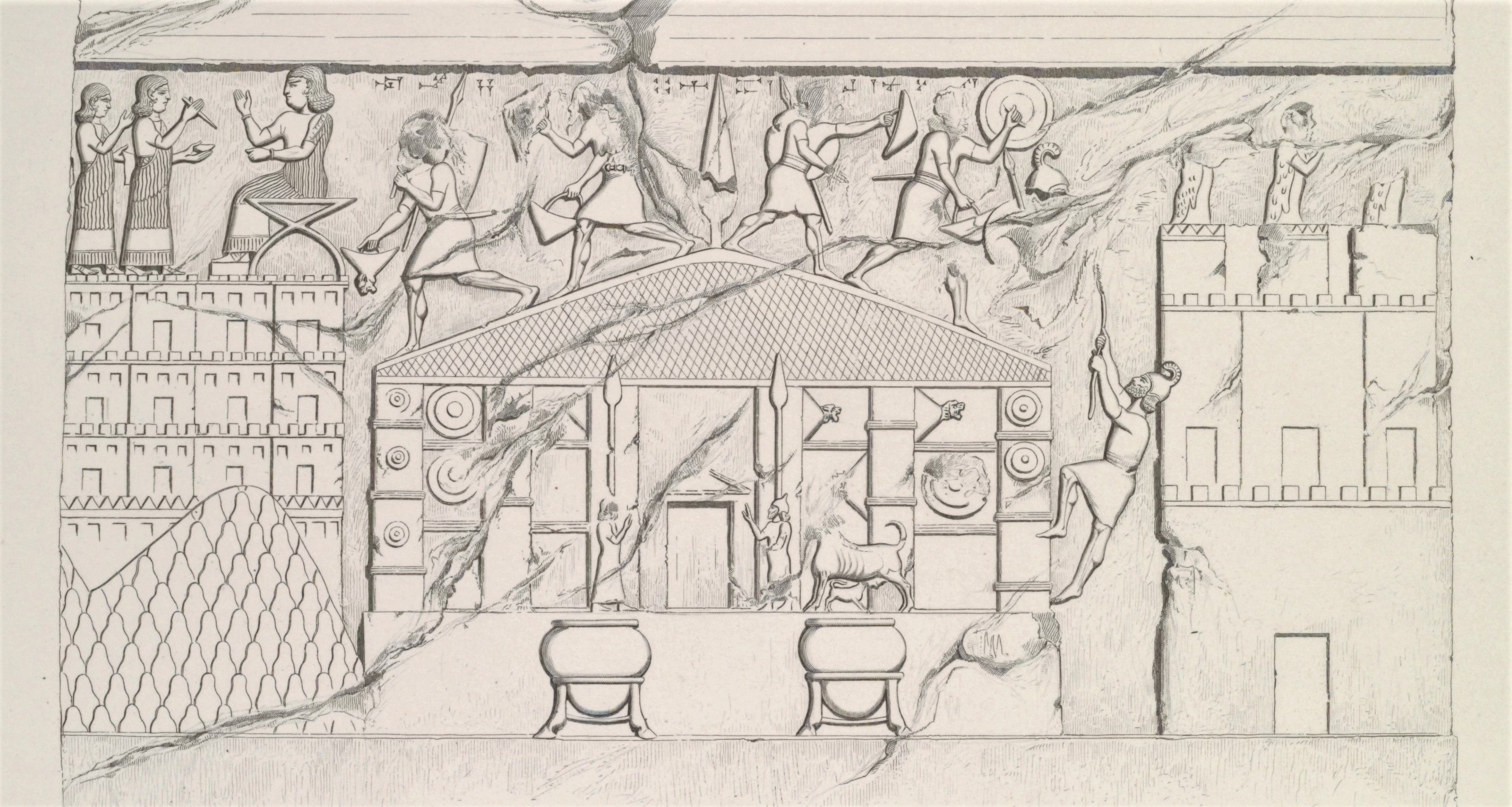
class="w-full max-w-3xl mx-auto border border-white/10 group-hover:border-[var(--color-brand-orange)] transition-all"
loading="lazy" />
Figure 2.2: Muṣaṣir Relief. Sargon II's Palace at Khorsabad, Room XIII, Slab 4
(click to enlarge)
Events following the sack of Muṣaṣir in 714 BCE are conjecture, although Roaf’s narrative is most compelling. A primary point of dispute is the dating of the Topzawa Stele. As previously discussed, the Topzawa Stele was erected along the Topzawa Çay in the Sidekan area, and its text contains details in both Assyrian and Urartian about Rusa S’s journey to Muṣaṣir. The text commemorates the travel of Rusa, son of Sarduri, who declares in his first year, he went to Muṣaṣir. Urzana, the king of Muṣaṣir, greets Rusa and pledges loyalty to Urartu. In turn, Rusa S places Urzana as governor of the protectorate. In the Assyrian version of the text, Rusa declares that he moved into the mountains of Assyria, killing his enemies. Once entering Muṣaṣir, he sacrifices animals in honor of Ḫaldi and hosts a festival for the kingdom's people (Mayer 2013, 83–85). The Movana and Mergeh Karvah stelae add slightly more information, and their locations suggest a sort of processional journey to Muṣaṣir along the main route between Lake Van and the Kelishin Pass. In the Urartian version of the Movana stele and Assyrian version of the Mergeh Karvah stele, the mountain that Rusa forces the Assyrians from is named Andarutu, the same mountain Sargon II describes moving past to reach Assyria (Salvini 2008, 497–508).
The date of Rusa S’s travel depends entirely on reconstructing the order of Rusa S and Rusa E. If one assumes Rusa S was the adversary described in Sargon II’s eighth campaign, the events must occur before the sacking of Muṣaṣir, given the text commemorates the king’s first year of rule. This interpretation requires the assumption that the suicide of Rusa described in the account of the eighth campaign occurred after the events of the campaign, sometime later in 714 BCE. In that scenario, the death happened while the Assyrians occupied Muṣaṣir. Contrastingly, if Rusa E reigned after Sarduri and before Rusa S, the events described on the stelae indicate an Urartian reconquest of Muṣaṣir.
Under a reconstruction where Rusa S follows Rusa E, the Assyrian rule in Muṣaṣir lasts a short time. The only specific date that establishes activity at Muṣaṣir following the campaign is in the Assyrian Eponym Chronicle. In the year 713 BCE, a broken piece of the text alludes to something happening in Muṣaṣir, although the nature of the occurrence is unknown (Millard 1994, 47). Eleven letters from Sargon II’s spies and emissaries in the mountains around Assyria report on events in Muṣaṣir, four of which mention Urzana. One letter contains a report by Urzana to Sargon II, informing him that the Urartian king is on his way to Muṣaṣir. Urzana notes that while Sargon II commanded that no one “may take part in the service without the king’s permission,” that “when the King of Assyria came here, could I hold him back? He did what he did.” The letter does not have associated contextual information confirming the date or who Urzana must hold back, but the “service” described seems to be a pilgrimage at Muṣaṣir and “he did what he did” referred to Sargon II’s conquest of Muṣaṣir. Thus, the letter must describe events after Sargon II conquered Muṣaṣir but while he still reigned over the kingdom.
Two letters may describe events while Muṣaṣir is under Urartian control. In one, an Assyrian emissary reports that Urzana is traveling to see the Urartian king soon after the invasion by the Cimmerians, dating the letter after Sargon II’s eighth campaign. Another letter describes a man named Abalunqunu as the governor of Muṣaṣir. Given that Urzana is in control during Sargon II’s reign over Muṣaṣir, this may suggest the governing official held office after the Muṣaṣir reconquest. One report by Aššur-rešua relays to Sargon II that the Urartians seized Urzana and took him to Waisi in Urartu. In sum, these texts, plus the Topzawa text, suggest that after the capture of Muṣaṣir by Sargon II, the Assyrians control the kingdom for one to two years. Rusa E committed suicide or, more likely, Rusa S overthrew and replaced Rusa E in response to the Urartian defeat and humiliation by the Assyrian forces. Soon after, Rusa S musters his Urartian forces and travels to Muṣaṣir, capturing the kingdom and killing any remaining Assyrian forces in the area. Rusa S’s rule was short, as only a few years later, by 709, Argišti rules Urartu (Roaf 2012a; 2012b).
After this period full of historical records and mentions, the references to Muṣaṣir mostly disappear. Muṣaṣir/Ardini does not appear in any of the inscriptions of the later Urartian kings, and none of the inscriptions or letters by the later Assyrian kings mention the kingdom. However, worship of Ḫaldi by the Urartian kings continues, suggesting that the temple continued operating in the succeeding decades. Further suggestive evidence of the continuation of the cult of Ḫaldi, and possibly the temple at Muṣaṣir, comes from Assyria. Examining the prosopography of the Neo-Assyrian Empire, 17 personal names occur with the prefix “Ḫaldi.” Seven of the seventeen names date to kings ruling after Sargon II. While three are undatable, one person, Ḫaldi-remanni, lived during the reign of Tiglath-pileser, and three others lived concurrently with Sargon II (Parpola 1998, 441–43). This continuity of names referencing the Muṣaṣirian god indicates continued worship or prominence of Ḫaldi. While this does not confirm the temple's existence, further evidence suggests an ongoing presence there.
Post-Assyrian Period – Ottoman Period
After the sack of Muṣaṣir by Sargon II, references to this area quickly taper off and disappear. While archaeological evidence suggests a moderately sized occupation during the Achaemenid Period, historical sources describing an area called Muṣaṣir are nonexistent during the period. Determining the possible identity of the region is a vital piece in reconstructing the importance and fate of Muṣaṣir. While the following section does not propose a definitive identification through the ensuing millennia, the process of combing through travelers' accounts, religious tales, and the accounts of empires is an effort to determine if this area maintained prominence during these many years. After the sack of Muṣaṣir, the area’s identity is unknown until the rise of the Sorani Emirate kingdom in 1500 CE.
After the fall of Assyria and Urartu, the last remaining preeminent state in the region was Media. According to Herodotus, Deioces united the various Median tribes into one kingdom in 678 BCE. Despite the likely embellishments of Herodotus’s account, including the misapplication of the ruler Deioces to this period, the founding of the Median kingdom, which would eventually grow to span across all of the Iranian plateau, likely did occur around that time (Diakonoff 2000, 89–90). Deioces’s grandson, Cyaxares, sacked Assyria and subsequently united the Iranian plateau under the Median Empire (550BC-330BCE) (Kuhrt 1994, 647, 656). While Herodotus’s accounts described a unified Median state stretching from Anatolia to Central Asia, contemporary Assyrian accounts do not support that geographic extent (Radner 2013). Indeed, the existence of a wide-ranging Median Empire is in doubt (Diakonoff 2000; Lanfranchi, Roaf, and Rollinger 2003, 397–402).
In the context of control of northwest Iran and the existence of Muṣaṣir, the eastern extent of the Median Empire is mainly irrelevant. In 616 BCE, Mannea and its Assyrian allies fought and lost a battle against Babylon at Qablin. While Assyria regrouped, Mannea’s weakness led to its defeat by Media, sometime between 615 and 611 BCE (Diakonoff 2000, 122). Mannea may have exerted some degree of independence, but by 590 BCE, when Cyaxares went to war in the west, it became fully integrated into Media as a subservient province (Diakonoff 2000, 125). Sources from Media itself during this time are limited or non-existent, and the archaeological record does little to explain the nature and extent of Media (Diakonoff 2000). Nevertheless, evidence points to the continuity of Mannea, in some form, after its integration into the Median state. During Herodotus’ alleged travel of the Royal Persian road, in the 5th century BCE, during the later Achaemenid Empire, he describes a place called Matiene, located around the river crossings of the Tigris, Great Zab, Lesser Zab, and Diyala Rivers (Tuplin 2003, 363). Mannea may continue as Matiene before the Achaemenid Empire eventually consumes the polity. However, Matiene’s identity is far from certain. Tuplin proposes that either Herodotus or a later copy of his work misattributed Matiene to Media or was a wholly inaccurate term (Tuplin 2003, 363). In Strabo’s account of his travels, written in the early 1st century CE, Media and Matiene [Matiani] are separate entities.
Further evidence of Matiene’s location around Lake Urmia, the original homeland of Mannea, comes from a contemporary of Strabo’s, Xanthus, who calls Lake Urmia “Lake Matianus,” and from Herodotus, who describes the Zagros as the “Matienian Mountains,” clearly taking their names from the surrounding land of Matiene (How and Wells 1991, 1.72.3). These Western travelers and scholars help establish the continuity of Matiene through at least the Achaemenid Empire. If the area of Sidekan and Soran did not fall under the authority of Mateine or Media, they might have fallen under the nominal jurisdiction of the Neo-Babylonian governors in Assyria (Kuhrt 1994, 540, 589–97). Most likely, this region maintained independence from its two neighboring empires, protected by the impassable mountains on all sides.
Following the end of the Median Empire, the Persians created an empire stretching from India to Greece, including all of the Zagros region (Kuhrt 1994, 656–67). The Persian rulers bestowed administrative duties on local governors called satraps to administer this immense territory. These satraps exerted varying degrees of control over their domain, depending on the geography and ethnic makeup of the area. For example, in the Zagros Mountains, much of the territory could not be fully integrated into the state and existed under only the nominal control of the Persian administrative authority (Kuhrt 1994, 689–92). Thus, Sidekan and the surrounding area were likely not tightly controlled by the Achaemenid ruling authorities, regardless of which satrap’s jurisdiction the region belonged to. Using Matiene as a guide, Sidekan/Muṣaṣir may have been in Herodotus’ 18th satrapy, consisting of “the Matienians and Saspeirans and Alarodians,” (How and Wells 1991, 1.82). However, Herodotus’s account of the districts of the Achaemenid Empire may be inaccurate given his reporting relied almost exclusively on the western satraps.
Historians traveling with the Macedonian king Alexander the Great recorded in great detail the administrative systems of the Persians, as the Macedonian king tended to co-opt the existing local systems rather than create new ones. While these records of the Achaemenid Empire’s come from the empire's fall during Alexander’s conquest, the greater detail in these accounts suggests some amount of accuracy. This structure divides the empire into seven large satrapies with smaller subdivisions. In this organization, Matiene was part of Media, in the satrap of “Central Minor Media,” bounded mostly by Parthia in the east, Elburz Mountains in the north, the Cosseans (roughly equal to modern Kermanshah) in the south, and the Zagros Mountains in the west (Bruno 2011). Given Sidekan’s location along the chaine magistrale of the Zagros Mountains, the area may have fallen under the authority of Media or the satrapy to the west, Arbelitis/Sagartia/Asagarta, roughly equivalent to the modern Erbil province. Considerable disagreement exists regarding Sagartia/Asagarta’s extent around Erbil, with opinions ranging from a vast area reaching the Caspian Sea or a province limited to Persian domains west of the Zagros Mountains (Eilers 1987, 701). These bureaucratic designations continue through the Achaemenid Empire and Alexander’s conquest until his untimely death and the subsequent division of his short-lived empire by his many generals (Schottky 1989; Kosmin 2013).
Notwithstanding the exact satrapy that Muṣaṣir fell under, archaeological and circumstantial evidence suggests the worship of Ḫaldi continued in the area. The latest historical reference to Ḫaldi comes during this period, centuries after Sargon II’s sack of the temple. In the autobiographical Behistun Inscription of the Achaemenid king Darius I (522-486 BCE), the ruler describes a revolution in Babylon by an Armenian named Arkha, the so-called Nebuchadnezzar IV, and calls him the “Son of Ḫaldita” (Oppenheim 1985, 561). The Old Persian version of the text states Arkha was Armenian while the Babylonian calls him an Urartian, likely indicating the geographic homeland of the Babylonian usurper rather than suggesting the Urartian kingdom’s continued existence (Beaulieu 2014, 18). Regardless, Arkha’s origin in the heartland of Urartu and Ḫaldi and his father’s name suggests some degree of continued reverence to the god through the 5th century BCE. While the continuation of the name Ḫaldi does not confirm a religious cult to the god or a temple at Muṣaṣir, archaeological evidence from the Sidekan subdistrict shows an occupation of the area by an Achaemenid populace with elite goods (Chapter 4 & 5). Thus, the population of Muṣaṣir was undoubtedly aware of Ḫaldi, suggesting a temple to the god remained through at least this period. However, following the fall of the Achaemenid Empire, the historical record makes no further reference to Ḫaldi, and the archaeological record falls silent for centuries.
At the end of the Achaemenid Period, the surrounding region takes on a new name, Media Atropatene. During the Macedonian invasion, an Achaemenid satrap named Atropates commanded Media for the Persians under the final Persian king, Darius III. With the arrival of the Macedonian armies, Atropates switched his allegiance to Alexander (356-323 BCE). Texts record Atropates' newfound loyalty to Alexander, resulting in his reinstatement as the satrap of Media under Macedonian rule and his eventual marriage to Alexander’s daughter (Arrian. 1860, 7.4.5). Upon the death of Alexander, the Macedonian generals divided up the empire, leaving the foreigner Atropates with the small subdivision “Little Media,” the minor northwestern part of Media around Lake Urmia (Chaumont 1987). Unwilling to be a vassal of a Macedonian general, Atropates established an independent kingdom thereafter known as Media Atropatene (Schippmann 1987, 222). In Schwarz’s (1969, 61) study of Media Atropatene, he postulates that the kingdom extended from the shore of the Caspian Sea to the Zagros Mountains, abutting the Sidekan area. While contemporary scholarly works detailing the geographic limits of empires and kingdoms often divide territories using the peaks of the Zagros Mountains, Iron Age Muṣaṣir’s eastward-facing allegiances provide evidence that the political boundaries may not have always aligned with the region’s topography. Thus, Media Atropatene’s sphere of influence around Lake Urmia may have extended into the high valleys of the Zagros Mountains in Sidekan.
Despite its modest size, Media Atropatene maintained its independence from the far larger Seleucid Empire (312-64 BCE) (Kosmin 2013; Strootman 2015). However, after nearly a century of autonomous rule, in 220 BCE, the Atropatene ruler Artabazanes pledged allegiance to the contemporary Seleucid king Antiochus III, seemingly forced into servitude following his support of a revolt by Molon, the satrap of Media, against the Seleucids. Antiochus III marched against Artabazanes, bringing the latter’s kingdom under the control of the Seleucid Empire as a proxy kingdom (Strootman 2015; Champion, n.d., 5.55.1-2). Even after Media Atropatene’s integration into the Seleucid Empire, the Atropatene royalty continued to administer the region.
Not long after Atropatene’s integration into the Seleucid Empire, the Parthian king Mithridates I took advantage of Seleucid weakness following defeats by Roman forces and conquered the Median satrapies. By 148 BCE, the Median territories fell under the administration of the Upper Satrapies of the Parthian Empire (Schippmann 1987, 223, 24). However, despite Parthian rule, Atropatene’s rulers maintained some degree of autonomy. To maintain a good relationship with its northern population, Parthian royalty engaged in marriage pacts with the elites of Atropatene, seemingly electing to use influence rather than force to maintain control of these lands (Minorsky 1964, 188). More than a century later, in 36 BCE, Atropatene’s autonomy ended with a failed alliance between the Roman general Marc Antony against the Parthians (Schippmann 1971, 309; Ziegler 1964, 36). Following the war against Marc Antony, the Parthians severely curtailed Atropatenean independence, eliminating the control by the royal dynasty in 10 CE (Kahrstedt 1950, 18; Ziegler 1964, 60). After the Sasanian conquest of Parthia in 226 CE, Atropatene’s name changes again to Aturpatakan, the origin of the modern name Azerbaijan.
While royal records do not identify the region of modern Sidekan during the Achaemenid, Seleucid, and Parthian periods, ecclesiastical sources from the Nestorian church provide clues. Many Nestorian communities date back to the 5th century CE and have retained their names, helping locate historic locations using modern names as anchor points. For example, the Iraqi province of Erbil largely corresponds to the ecclesiastical province of Adiabene. A significant diocese in that province was Hanitha (a.k.a Hnita and Hebton), located “in the valley of the Great Zab between ‘Aqra and Rowanduz” (Wilmshurst 2000, 166). This description establishes Hanitha in the area around modern Khalifan or Harir, located across the Rowanduz Gorge from the modern Diana and Sidekan subdistricts. Further, the neighboring diocese is Salah, “located to the east of Rowanduz,” which, given that the Urmi province contained Lake Urmia, must lie around the area of Choman (Wilmshurst 2000, 166, 275–76). While available records do not indicate which Nestorian diocese Rowanduz and Sidekan fell under, Nestorians undoubtedly occupied these areas, with Nestorian communities documented in Diana and Sidekan until at least the 19th century CE (Ainsworth 1841, 69; Boehmer and Fenner 1973, 519–20; Wilmshurst 2000, 174).
Despite the known Nestorian occupation, the name of Sidekan during this time remains unknown. However, a 4th century CE Syriac text provides a clue about the name of the area north of Sidekan. In the text, The History of the Heroic Deeds of Mar Qardagh, the protagonist, Qardagh, travels from the lowlands of Adiabene to see a “certain blessed man” named Abdišo “in a mountain cave of Beth Bgash” (Walker 2006). According to Nestorian toponyms, Beth Bgash is in “the high and majestic mountains” and should be “between the upper reaches of the Great Zab River and Lake Urmi[a]” and thus part of the diocese of Shemsdin (Walker 2006). The Nestorian Shemsdin district, modern Şemdinli, is located near the modern border between Turkey and the northern edge of the Sidekan district (Wilmshurst 2000, 279–83). Thus, Beth Bgash is located somewhere in this mountainous area currently controlled by the PKK, likely north of the Rukuchuk Gorge. While possibly in the far limits of the large Sidekan subdistrict, Beth Bgash was unlikely near the main habitation center around modern Sidekan town. However, the sacred connection of caves in this region is a relevant detail for understanding the emergence Ḫaldi cult.
With imperial or Nestorian sources failing to identify the area, western Classical accounts may provide possible toponyms. During Henry Rawlinson’s travels over the Kelishin pass, he postulated on the classical names for these territories. One possible identification he ascribed to Kelishin was the road “described to Xenophon when he was at the foot of the Carduchian mountains” (Rawlinson 1840, 23). Xenophon’s account describes the Carducian mountains as a place to go on the journey to Armenia, coming from the lower Tigris (Xenophon. 2008, 4.1). In the Carduchian Mountains are the headwaters of the Tigris, which is traditionally considered Anatolia, but the source of the Upper Zab in the Zagros Mountains may also be considered the headwaters of the Tigris River (Dandamayev 1990). Around Carduchia, Rawlinson describes the country of Anisenes (Rawlinson 1840, 18). The Anisenes Rawlinson notes here may relate to another entity called Azoni. Pliny the Elder, in his Natural History, writes of an entity called Azoni, in which the “Zerbis” (Great Zab) flows. Adjoining Azoni is “the mountain tribe of the Silices and the Orontes, west of whom is the town of Gaugamela” (Pliny 1855, VI.181). Given that Gaugamela was somewhere between Dohuk and Irbil, and the Orontes here refers to the Upper Zab, the west of the town would be the foothills and mountains of the Zagros Mountains, corresponding to the general area of Sidekan (Lane Fox 1986, 228–43).
More concrete evidence favoring placing Aniseni/Anzoni around Rowanduz and Sidekan comes from a 591 CE report of a Byzantine campaign into Iran. Emperor Maurice sent Roman soldiers to assist the exiled Sasanian king Xurso II in defeating the usurper Bahram Chobin (Daryaee 2008, 80–83). In the Byzantine account, the detachment of Greek Byzantine soldiers works its way from the Mesopotamian plains into the mountains. They first occupy Irbil and then move to Hanitha, located near the modern towns of Khalifan or Harir. Bahram Chobin captures a bridge on the Upper Zab River to prevent these forces from joining up with Armenian troops marching from the north. With their original plan to combine forces on the western side of the Zagros Mountains ruined, the Byzantine army invades Aniseni to reach the eastern bank of the Upper Zab (Mionrsky 1944, 244–45). They then move to a village named “Siraganon.” Armenian forces eventually met up with Byzantine general Narses, coming from Armenia, and Xurso II’s army on the eastern side of the Zagros Mountains. Thus, following the itinerary, Aniseni was somewhere between the upper reaches of the Upper Zab River and the Lake Urmia basin, placing it in the general area of Rowanduz and Sidekan. The army must have moved through this area to reach the Urmia basin, avoiding the Upper Zab's widest and least crossable portions. Rawlinson identified Siraganon with the modern village of Qal’a Singan, just to the east of the Kelishin Pass in the Urmia Basin, which would place Aniseni west of the Kelishin Pass. Further evidence for locating Aniseni near Sidekan is the name of a local tribe in that area mentioned by 19th-century travelers, Pireseni (a.k.a “Piresui,” “Pirastini”) (Rawlinson 1840, 25; Sykes 1908, 458). The names’ similarity may indicate a continuation throughout time.
Moving forward almost a millennium, the Muslim Il-khanate (~1250-1350 CE) ruled over most of modern Iran and Iraq, with a known presence at Hasanlu Tepe, not far from the Kelishin Pass (Danti 2004; Amitai 2007). Given the power and proximity of the Il-khanates, its rulers likely exerted influence or control over the inhabitants of the Sidekan subdistrict. Not long after the disintegration of the Il-khanate, in the late 14th century, an Arab Muslim traveler and geographer named al-Qalqashandi passed through the area around modern Sidekan. He described three stone stelae made from “greenish stone,” which almost certainly refer to the Topzawa, Kelishin, and Merg-e-Karvan inscriptions. The “Zarazarian” tribe then guarded at least one of the stelae, right below the “Janjarain” mountain (al-Qalqashandi 1973, 376; Marf 2014, 13). Accounts in the 19th century connect the Zerza Kurds to the Zarazarian tribe, residing on the border between Iraq and Iran, with a large contingent in the Ushnu valley (Ainsworth 1841, 63; Baillie and Bentley 1856, 89; Sykes 1908, 461). The tribe’s name is perhaps connected to Muṣaṣir and the Urartians. In the Movana Stele, Rusa declares he made a sacrifice of sheep in the city of “Zarzar[u],” a name that bears striking similarity to al-Qalqashandi’s “Zarazarian” tribe and would correspond to roughly similar areas (André-Salvini and Salvini 2002, 21; Roaf 2007).
Not long after al-Qalqashandi’s travels, a Persian author writes a detailed history of the region that establishes the name of the surrounding region going forward in time. The text is a 16th century CE account called the Sharafnama, detailing the founding of Kurdistan, with a chapter devoted to the Soran tribe. This account is the oldest text that firmly establishes the identity of this area as Soran and Rowanduz. The author of the Sharafnama, Prince Sharaf al-Din Bitlisi, was a Rozhiki prince taking refuge in the Safavid court after the ousting of his dynasty by the Ottomans (Bidlīsī and Izady 2005, xvii). While the author takes some poetic license, the known sections follow external historical events and thus provide a useful source for determining early Kurdish history. Book Three, Part Two, and Chapter One details the history of the Sorani Emirate. While the tale is primarily helpful for establishing geographical names, the overall story of the dynasty also assists in understanding the character of the area’s peoples.
Figure 2.3 not yet available
Figure 2.3 not yet available
The first ruler of Soran was a man named Kolous, an Arab from Baghdad who emigrated to Houdian (Hawdian) village. His eldest son, Iça, raised an army and captured the canton of Awan (Rowanduz). In the tale, his soldiers scaled the “red rocks” that surround the fortress. This apocryphal story establishes the etymology of the Soran clan – the name refers to their ability to climb the red rocks. After capturing the castle, Iça consolidates the area and names it Soran. His son, Shah Ali-Beg, took the throne and split the domain between his four sons. The eldest son, Mir Iça, ruled from Harir but was soon killed by a rival king from the western Baban tribe named Pir Boudaq. One of Mir Iça’s brothers, also named Pir Boudaq, ruled from the town of Soumaq'liq, and another, Mir Ali, from Cheq’-Abad. After Mir Iça’s death and the Baban tribe captured his territory, Mir Ali fought and killed his brother Pir Boudaq, enlarging his realm to include all of Irbil, Mosul, Kirkuk, and Q’izilbaches. His son 'lzz-u'ddin Chir took on this sizeable kingdom after his father’s death. In 1534 CE, the Ottoman Sultan Suleiman I (1520-1566 CE) conquered Baghdad and took control of Irbil, granting authority to a rival Kurdish prince, Hussein-Beg Daciny. Soon after, the Ottoman sultan executed 'lzz-u'ddin Chir, adding Soran’s territories to Hussein-Beg Daciny’s realm.
After 'lzz-u'ddin Chir’s death, the great-grandson of Shah Ali-Beg, Mir Se'if-u’ddin, ruling from Soumaq'liq, fought numerous battles with Hussein-Beg Daciny, before attempting to take refuge in Iran. He returned to his family’s domain and defeated Hussein-Beg Daciny after a series of conflicts. Sultan Suleiman executed the defeated Hussein-Beg Daciny and raised an army of Kurdish emirs loyal to him to attack the Sorani ruler Mir Se'if-u’ddin. The attacks failed and Mir Se’if-u’ddin enjoyed control over his dominion for a few decades. Eventually, he traveled to the Ottoman court to ask for forgiveness and a permanent role as guardian of this kingdom, but the sultan executed him on arrival in the capital. A new leader arose to lead the Soran clan named Q'ouly-Beg, 'lzz-u'ddin Chir’s nephew. During the turmoil of the Ottoman invasions and executions, Q’uoly-Beg hid at the royal Safavid court in Iran, away from the Daciny tribe’s rule of Irbil and Soran. After the Daciny’s downfall, Q'ouly-Beg asked the Sultan to restore his hereditary land of Soran. Instead of granting his request, the Sultan gave him control of a distant area, the canton of Semawat, near Basra. Once Sultan Suleiman executed mir Se'if-u’ddin, the Ottoman leader rewarded Q'ouly-Beg for his loyalty by reassigning Q'ouly-Beg to rule his family’s ancestral home of Harir. Q'ouly-Beg reigned from Harir for twenty years. After his death, his two sons fought over Harir and control of Soran, with his younger son, Suleiman-Beg, eventually seizing control over the whole area.
With complete control of Soran, Suleiman-Beg led a campaign against “the great tribe of Zerza” with an alleged 13,000 Kurdish infantry and cavalry (Charmoy and Bidlīsī 1868, 134; Bidlīsī and Izady 2005). This Zerza tribe is almost certainly the same tribe al-Qalqashandi spoke of in his accounts a few centuries before, now known as Zerza. Importantly, this suggests the Sidekan area maintained autonomy even from its direct neighbors in Soran and the continued presence of a sizable population in the 16th century CE. Suleiman-Beg defeated the tribe, sending the surviving members to the court of the current Ottoman Sultan, Murad III (1574-1595 CE), to plead their grievances against the Kurdish ruler and request assistance. The tale describes a fortuitous occurrence of Suleiman-Beg capturing many Persians and sending them to Istanbul, earning him the goodwill of the Sultan and a pardon. Expanding his power, Suleiman-Beg attacked a cousin, Q’odbad-Beg, in 1586 CE, killing his cousin, fourteen family members, and seizing the territory of Terek (Charmoy and Bidlīsī 1868, 127–35). Regarding Terek’s identity, Rawlinson notes a tribe, “which borders upon Sidek [Sidekan] northward” called “Terkur,” possibly referring to the same entity that Suleiman-Beg attacked (Rawlinson 1840, 26). From that point, Suleiman-Beg reigned with absolute power and neighboring rulers were forced to obey him. The author of the Sharafnama, Bitlisi, was a contemporary of Suleiman Beg, ending the story in the late 16th century CE.
A few synchronisms allow a rough reconstruction of early Sorani chronology. The author gives two exact dates, 1586 CE, during the rule of the last Suleiman-Beg, and 1534 CE, with the Ottoman capture of Baghdad during 'lzz-u'ddin Chir’s reign. 'lzz-u'ddin Chir was the great-great-grandson of the dynasty’s founder, Kolous. The given information does not provide enough data to allow us to calculate the exact reign of each generation but using the tales of their reigns enables a rough estimate. Mir Ali established a strong domain, his father Shah Ali-Beg reigned over a large area but did not necessarily expand it, and his father, Iça captured Awan and built the dynasty into an emirate. As a comparison, roughly 50 years passed between the end 'lzz-u'ddin Chir’s reign and a significant battle during Suleiman-Beg’s reign, a period of three generations. However, those generations’ longevity was shortened by the Ottoman sultan's executions of the Sorani rulers. Using the metric, assuming 25 years between 'lzz-u'ddin Chir and Iça is a reasonable estimate. Thus, Iça’s rule would have begun sometime around 1450 CE, with his father’s original journey to Hawdian at the beginning of that century, not long after al-Qalqashandi passed through the area.
Ottoman Empire & Sorani Emirate
After integration into the Ottoman Empire in 1586 CE, the Sorani Emirate seemingly disappears from the textual record for several centuries, existing as a component of the vast empire, at least in records currently available. A deep-dive into the imperial Ottoman archives in Istanbul might find further information about the administration of Soran, but they remain inaccessible to me and are outside the scope of this dissertation. In the 19th century, however, a strong ruler rose from the Sorani Emirate named Muhammad Kor. The expanding interests of the great powers of Europe in the Middle East and the accounts of travelers in the area provide information on him. In 1813, the Sorani emir Muhammad ‘Kor’ (a.k.a Kor Pasha, the “Blind Pasha”) came to power in Rowanduz and began consolidating authority in the surrounding areas (Rawlinson 1840, 25).
Before the rise of Muhammad Kor, Sidekan had been a domain of the prince of Amadiya, located in the northwest. As the Sorani emir rose to power, he consolidated power in Soran and gained control of its immediate neighbors (Rawlinson 1840, 25). By eliminating any rivals in his emirate, he quickly gained complete command and the allegiance of the surrounding Kurdish emirates (McDowall 2004). While technically under the control of the Ottoman sultans for centuries, the empire left the individual rulers, derebeys (i.e. “valley lords), in control of their fiefdoms (McDowall 2004). This autonomy made the conquest of individual emirates by other Ottoman emirs possible without directly invoking the sultan's wrath in Istanbul. Muhammad Kor amassed influence and created alliances with the tribes of Baradost, Surchi, Mamash, and Shirwan before conquering and taking control of the neighboring Kurdish emirates. In the 1820s he expanded his power by conquering the Ottoman valis of Hakkari, Baban, and Bahdinan, located in the area of Amadiya (Eppel 2008, 250). Because of Muhammad Kor’s power and firm control over the population, the Ottoman governor in Baghdad bestowed upon him the title of Pasha, but he continued to expand his domain (McDowall 2004).
Expanding northward up the Tigris River, Muhammad Kor attacked the Buhtan Emirate before withdrawing and consolidating his gains (Eppel 2008, 250). At this point, his emirate stretched hundreds of kilometers across the Zagros Mountains and the piedmont regions, from Rania in the east, to Jebel Sinjar in the northwest, Hakkari in the north, and Erbil in the southwest. During the decade at the pinnacle of his power, he became the de facto ruler of this region. With this newfound power, Muhammad Kor employed Persian and Turkish experts to construct factories around Rowanduz, producing artillery, shells, rifles, and other weapons in addition to minting coins bearing his name (Eppel 2008, 250). Nearly a century later, Hamilton, surveying the landscape, saw the remains of the lower Rowanduz town, the location of Muhammad Kor’s weapons factories (Hamilton 2004, 85). The total strength of his army allegedly numbered 10,000 cavalry and 20,000 infantry, providing him with a considerable measure of security (Djali 1973). However, despite his consolidation of power, Muhammad Kor remained a vassal of the Ottoman Empire, and the increasingly power-hungry Kurd began to pose a threat to the central government.
When Ottoman Sultan Mahmoud II (1808-1839 CE) ascended to the throne, he attempted to eliminate the semi-autonomous rulers inside the Ottoman Empire and bring them under stronger central control (McDowall 2004). As a far-flung and challenging part of the empire to access, Kurdistan and the inhabitants in the Zagros Mountains evaded the initial move towards centralization (McDowall 2004). Muhammad Kor’s autonomous state in the Zagros Mountain and desire for further power eventually made him a target of the Ottoman sultan. Concurrent with the rise of the Sorani Emirate, Egypt, under Muhammad Ali, exerted considerable pressure against the empire, including an attempted overthrow of the sultan. In 1832 Muhammad Ali and his Egyptian forces captured the Levantine city of Acre and marched north into Anatolia itself, defeating the Sultan’s army (Al-Sayyid Marsot 1984). With the Ottoman throne threatened by Muhammad Ali, the Sultan feared an alliance between Egypt and Soran, an existential threat that would effectively cut the empire in half. In response, Sultan Mahmud II launched an attack against the Sorani Emirate in 1834 (Eppel 2008, 251).
The sultan’s Grand Vizier, Muhammad Rashid Pasha, marched against Muhammad Kor with a large force of troops from Anatolia, Mosul, and Baghdad, while a British emissary simultaneously attempted to broker peace. Like millennia before, the Rowanduz Gorge presented a formidable and dangerous barrier that would ensure significant casualties on both sides. A British officer involved in the situation, Robert Wood, believed Muhammad Rashid Pasha was rash, and his reckless actions would unintentionally lead to the strengthening of the Qajar Dynasty in Persia, against the interests of the British (Cunningham 1966). He arranged with the governor of Baghdad, Ali Ridha Pasha, to facilitate a meeting with Muhammad Kor, in which he could resolve the conflict peacefully. Upon arriving in Rowanduz, Wood found a Persian agent persuading Muhammad Kor to escape to Iran and ally with the Persians against the Ottoman Empire. According to Wood, he informed Muhammad Kor that the Persians were simultaneously allying with the Ottomans to quash the nascent Kurdish state, and the arrival of Muhammad Rashid’s forces was imminent. Wood’s argument of an impending Persian and Ottoman alliance is somewhat doubtful and may have been a strategic tactic, lie, or embellishment on the part of the British officer. Regardless, negotiating between the competing interests of Muhammad Kor, the Ottoman sultan, and Qajar Persia, Wood arranged for Muhammad Kor to travel to Constantinople, pledge allegiance, and return as a buffer against Iran.
Trapped between two much stronger entities, Muhammad Kor acquiesced and agreed to travel to Constantinople (Cunningham 1966: 104-106). The Ottoman authorities likely never intended to follow through with this plan, given their new practice of eliminating hereditary rule in the provinces. The journey to the Ottoman capital progressed without notable incident, but Muhammad Kor was killed on his return journey, likely by Ottoman factions not wishing to see the Kurdish ruler reinstalled (McDowall 2004; Eppel 2008). After that point, the Ottoman Empire absorbed Soran and Rowanduz into the empire’s centralized system.
Despite full integration into the Ottoman Empire in the mid-19th century, the effect of either Ottoman or Persian rule throughout its history is minimal. Masters notes in his dissertation on Rowanduz that “the control of the Iranians and Turks was thus largely confined to the maintenance of police posts and army installations and the attempt, often in vain, to maintain public order and collect a few taxes” (1954, 10). While the focus of this dissertation is on the Sidekan area, the historical references concerning Rowanduz are significantly more robust, and the city was the nearest major center to Sidekan for much of recent history. After Muhammad Kor’s fall, Rowanduz continued as the region's center, controlling the district that would later become Soran. Prior to the formation of Iraq following World War I, the Ottoman forces maintained a small garrison of two battalions of infantry and a police detachment (Masters 1954, 13).
During this late period of the Ottoman Empire, Jewish subjects continued to live and thrive at Diana before migrating to Erbil and Mosul. Their eventual immigration to the west led to physical and oral records that recent scholars used to reconstruct their actions in the area during the 18th century and before. Specifically, a tribe of Jews, the Binjamin clan, lived in Diana, mentioned earlier as a long-lasting bastion of Nestorians (Zaken 2007, 203). According to a living local inhabitant, Diana roughly translates as “the Christian enclave,” which confirms its history as a town for at least one religious minority and unsurprisingly home to other religious factions. In the 19th century, the head of the Binjamin clan, Moshe Binjamin, traveled up to “Sidaka” (a.k.a. Sidekan) to meet the tribal chief residing there, Mahmud Beg, the chief of the Pireseni tribe, mentioned above. The road from Diana to Sidekan was, even during this phase of relative peace under the Ottomans, still quite dangerous. On Moshe Binjamin’s journey back to his home in Diana, he was ambushed by another tribe in Shaikhan, near the base of the modern Sidekan road (Zaken 2007, 168–69). In addition to providing details on the names of the area during this time, the Jewish accounts create a narrative of the danger and difficulty of reaching the isolated area of Sidekan.
Modern: Iran/Iraq War
After World War I, the colonial powers divided up the Ottoman territories, combining the vilayats of Baghdad, Basra, and Mosul to create the modern state of Iraq. The Treaty of Lausanne, signed in 1926, split the Kurdish populations between Iraq, Syria, and Turkey. During the first few years of Iraqi independence, the country was under the administration of the British government, and also during this time, the Kurds revolted, attempting to gain their autonomy and independence (Aziz 2011, 60–62). As Hamilton describes in his memoir, the British suppressed the revolts with airpower and the assistance of Assyrian Christian levies (Hamilton 2004, 64). The British accounts described the bombings as civilized, despite the loss of life they caused, in a sign of the era’s thinking. One purpose of Hamilton’s road constructed through the Rowanduz Gorge was integrating these previously isolated pockets in the Zagros Mountains into the rest of the country. After the British passed control of the county to the newly formed national Iraqi government, the Kurds continued rebelling against the central authority, forcing the retreat of a large contingent of Kurdish soldiers into Iran (Aziz 2011, 67).
Roughly three decades after Iraq’s independence, the country, then under the autocratic rule of Saddam Hussein, declared war on the newly formed Islamic Republic of Iran (Murray, n.d., 90–98). In addition to causing tens, if not hundreds, of thousands of deaths, the war and subsequent Anfal campaign against Kurdish rebels inexorably altered the landscape. Despite its distance from the main theaters of conflict, at least one military campaign occurred in the area of Rowanduz and Sidekan.
After months of conflict and periodic skirmishes, mainly through airstrikes, between Iraq and Iran through early 1980, war broke out in late 1980. In September, Iraqi ground forces invaded Iran’s southern province of Khuzestan, reaching the city of Ahvaz. Through the next year, Iraq advanced against Iran before Iran mobilized its forces (Murray, n.d., 110–50). Saddam Hussein, expecting a quick victory, was unprepared for Iran’s leader, Ayatollah Khomeini, to use the attack to consolidate power and raise the banner of holy war (Murray, n.d., 90–98). By 1981, the Iranian forces began taking back territory, which started seven years of mostly inefficient fighting. At the end of the conflict, in 1988, the only lasting result was a changed political situation in both countries and the proliferation of weapons throughout the region (Murray, n.d., 336–43). The many battles fought between these two countries were split into several discrete campaigns, with clearly defined dates. Record of these operations, combined with anecdotal and ethnographic evidence from fieldwork in Sidekan, provides rough tracking of the military actions in Sidekan (Murray and Woods 2014, 344–47).
Although the Kelishin pass near Sidekan afforded the Iranians an accessible route for invasion, few campaign accounts record the Iranians attacking this position. The most significant evidence confirming Iranian attacks in this area is detritus from military operations and anecdotes from locals who lived through the battles. These tales of the war can be combined with general histories of the entire war’s trajectory and various campaigns to determine the validity of anecdotal accounts. Older residents in Sidekan and Mudjesir discussed how many of the hilltops in the area, notably Qalaat Mudjesir, were utilized as anti-aircraft positions or emplacements for high ordinance weaponry. On a field at Mudjesir, the Iraqi Army allegedly flattened most of the area to clear space for a large artillery gun. In one attack, the Iranians moved past Kelishin, into Sidekan, and headed towards Soran and Mosul. How the Iraqis stopped the Iranian advance is unclear, but there is no evidence for conflict on the Diana Plain. Physical scars on the landscape around Sidekan corroborate much of this narrative. Hilltops like Qalaat Mudjesir show the telltale sign of military trenches around the edges and holes dug into the site either for storage or weapon emplacements. Satellite imagery reveals many more hills in the area with similar military trenches around the sides. Mudjesir, where the alleged flattening occurred, is littered with metal detritus, including spent shells and metal scraps.
The vast minefields around Sidekan further confirm extensive warfare in the area. Among others, the hills around the Topzawa Valley contain multiple minefields, although most of the lower slopes of the hills are either cleared or did not initially contain minefields. A more extensive minefield exists along the Old Sidekan Road, following the Sidekan and Barusk Rivers. This explosive barricade would have blocked any sizeable Iranian advance through the area in the case of a largescale attack. Despite clear evidence of the conflict, the military actions in this area were part of the more notable campaigns of the war.
Several Iranian campaigns attacked Iraq through Kurdistan’s eastern border, but most occurred near the Shahrizor Plain and Sulimaniyah, with a handful attempting to enter through the Gawra Shinke Pass (a.k.a. Piranshahar in Persian) near the town of Hajji Omaran. In 1983, 1985, and 1988, three primary campaigns attacked Iraq through the Gawra Shinke Pass, attempting to capture Rowanduz. None of the records of these attacks explicitly record an offensive over the Kelishin Pass, but a simultaneous secondary attack during these more significant offensives is possible. The first campaign, dubbed Dawn 2, began July 2, 1983, intending to defeat the Iranian Kurdish PDKI group hiding in Iraq. Iraqi Kurdish KDP forces, under the leadership of Mustafa Barzani, were allied with Iran and intended to stop the PDKI’s power in their homeland of Iraq. Iranian forces crossed the pass and penetrated 10 miles into Iraq before a series of fights stopped the advance at the town of Rayat, where they built trenches and other fortifications (Razoux and Elliott, n.d., 249). During this campaign, an Iranian general named Hassan Abshenasan was killed during a paratrooper operation at “Sarsul Kelishin,” according to multiple accounts on Iranian websites, but otherwise unconfirmed (Agency n.d.; “زندگینامه: حسن آبشناسان (1319 - 1365)” n.d.). Sarsul Kelishin may refer to a place called Sarsul located near Choman or to a “Kuh-e Sarsul” located directly on the other side of the border from the Kelishin Pass
Two years after Dawn 2, on September 8th, 1985, after losing some territory to Iraq, the Iranian military launched Operation Jerusalem 5. Its forces continued past Rayat, capturing it and reaching 20 miles east of Rowanduz. Strong Iraqi opposition there halted the Iranian advance and stabilized the front before the Iranians pulled back to their original position 12 miles inside Iraq (Razoux and Elliott, n.d., 330–31). Two years after Jerusalem 5, Iran launched an all-out assault, dubbed Kerbala 7, attacking northern Kurdistan, threatening Iraqi oil exports, and diverting Iraqi forces north. Although the Iranian forces were mostly successful in their short term objective of capturing the Gerdmand Heights and reaching within 10 miles of Rowanduz, they failed in either capturing the city or threatening Iraq’s oil fields (Cordesman 1994, 37–38; Razoux 2015, 397–98). For the Jerusalem 5 and Kerbala 7 attacks, no definite evidence exists of attacks over Kelishin, but given the full-scale offensive, they would likely have made use of this pass in at least one of these three campaigns. One alternative theory is that Iranian forces skirmished with Iraqi forces on the other side of the Kelishin Pass. Regardless, Iranian forces advanced into Iraqi Kurdistan at some point during the war, contributing to the destruction and alteration of the landscape.
After the Iran-Iraq War ended, Saddam Hussein carried out the systematic suppression of the Kurdish population, justifying the genocide as punishment for their role in supporting the invading Iranians. This operation was dubbed the “Anfal” and killed an estimated 100,000 Kurds in Iraq (Aziz 2011, 78–79). Other than the horrible loss of life, this genocide resulted in the further alteration of the landscape. One impact on the landscape was the construction of the “high road” in the Rowanduz Gorge, leading from Gali Ali Beg up to the town of Rowanduz, supposedly to facilitate easier access by Saddam Hussein’s tanks to squelch rebellions there. The road existed earlier in the twentieth century but as little more than a dirt path. Inadequate evidence exists on the precise date of the construction, but locals stated in conversations a construction date during the Anfal. Other military installments seemingly continued to be utilized by the Iraqi military or were reoccupied when rebellions arose. In addition to, modifications were caused by Kurdish rebels themselves, using high ground and caves as headquarters for attacks against the Iraqi forces. In addition to military alterations of the landscape, Saddam Hussein’s Ba’athist government also engaged in the process of “nationality correction,” which specifically relocated many small Kurdish villages in the area into larger, easier to control cities, like Soran (Aziz 2011, 78–79). This relocation resulted in the decay of relatively modern structures into the landscape, now nearly unrecognizable from the far more ancient ruins. The sum result of the military occupations during the Iran-Iraq War and its aftermath is a drastically altered landscape from millennia ago, requiring thorough investigations.